IMAGES TAKEN NEAR TO
Crescent Rise, LONDON, N22 7AW
Introduction
This page details the photographs taken nearby to Crescent Rise, N22 7AW by members of the Geograph project.
The Geograph project started in 2005 with the aim of publishing, organising and preserving representative images for every square kilometre of Great Britain, Ireland and the Isle of Man.

There are currently over 7.5m images from over14,400 individuals and you can help contribute to the project by visiting https://www.geograph.org.uk
Image Map
Images are licensed for reuse under creativecommons.org/licenses/by-sa/2.0
Notes
- Clicking on the map will re-center to the selected point.
- The higher the marker number, the further away the image location is from the centre of the postcode.
Image Listing (58 Images Found)
Images are licensed for reuse under creativecommons.org/licenses/by-sa/2.0
Image
Details
Distance

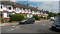
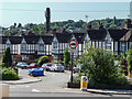
3
Crescent Rise
Seen from the junction with Durnsford Road. The road was laid out circa 1920 and initially formed part of Durnsford Road - it presumably took on the name Crescent Rise after Durnsford Road was extended to connect with Albert Road along its current routing. The housing was built between 1920 and 1935.
Image: © Martin Addison
Taken: 20 Jan 2012
0.02 miles
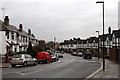
4

Houses in Crescent Rise
These semi-detached and terraced houses are in Crescent Rise a small residential road running south east from Durnsford Rd the B106 from Muswell hill to Southgate
Image: © Nigel Mykura
Taken: 23 Aug 2014
0.03 miles
6
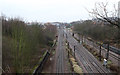
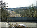
East Coast Mainline
Looking towards Alexandra Palace Station and Bounds Green Depot from Durnsford Road (above the south portal of Wood Green Tunnel). The bridge in the distance carries the Hertford Loop branch over the mainline - the red and green boxes visible on it are containers on a freight train.
Image: © Martin Addison
Taken: 20 Jan 2012
0.05 miles
7
View from above Wood Green Tunnel
The viewpoint is a small public garden.
Image: © Robin Webster
Taken: 6 Apr 2013
0.05 miles
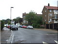
8
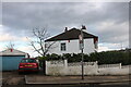
House on the corner of Crescent Rise from Durnsford Road
Image: © David Howard
Taken: 17 Mar 2021
0.05 miles
9
Crescent Rise, London N11
Crescent Rise is a turning off the south side of Durnsford Road.
Image: © Christine Matthews
Taken: 1 Aug 2013
0.05 miles
10
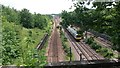
View over railway from Durnsford Road
The masonry at the bottom of the image is the tunnel parapet. This view is screened from the road by a high metal barrier.
Image: © David Martin
Taken: 25 Jun 2015
0.05 miles