IMAGES TAKEN NEAR TO
Albert Road, LONDON, N22 7AQ
Introduction
This page details the photographs taken nearby to Albert Road, N22 7AQ by members of the Geograph project.
The Geograph project started in 2005 with the aim of publishing, organising and preserving representative images for every square kilometre of Great Britain, Ireland and the Isle of Man.

There are currently over 7.5m images from over14,400 individuals and you can help contribute to the project by visiting https://www.geograph.org.uk
Image Map
Images are licensed for reuse under creativecommons.org/licenses/by-sa/2.0
Notes
- Clicking on the map will re-center to the selected point.
- The higher the marker number, the further away the image location is from the centre of the postcode.
Image Listing (57 Images Found)
Images are licensed for reuse under creativecommons.org/licenses/by-sa/2.0
Image
Details
Distance
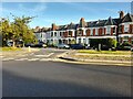
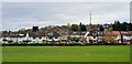
2
Durnsford Road, London N11
Looking towards Muswell Hill. Alexandra Palace can be seen on the horizon.
Image: © Christine Matthews
Taken: 4 May 2014
0.04 miles
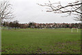
3
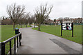
Albert Road Recreation Ground
On a site previously occupied by a clay pit and works, the land was first used to play football in the 1900's. It was later expanded to its present size. Tennis courts and bowls club were added in 1925. A full history can be found on the FARRG website at http://www.farrg.org.uk/index.php?option=com_content&view=article&id=9&Itemid=14 .
Image: © Martin Addison
Taken: 20 Jan 2012
0.05 miles

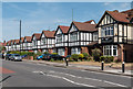
5
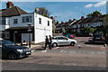
Clifton Road, London N22
As seen from Albert Road.
Image: © Christine Matthews
Taken: 4 May 2014
0.07 miles
6
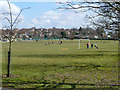
Albert Road Recreation Ground
A little Saturday morning football training is going on.
Image: © Robin Webster
Taken: 6 Apr 2013
0.08 miles
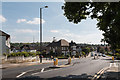
8
QR Tambo Recreation Ground, Durnsford Road
Looking towards Alexandra Palace. This was formerly the Albert Recreation Ground.
Image: © Christine Matthews
Taken: 13 Nov 2021
0.10 miles
9
Albert Road Recreation Ground
On a site previously occupied by a clay pit and works, the land was first used to play football in the 1900's. It was later expanded to its present size. Tennis courts and bowls club were added in 1925. A full history can be found on the FARRG website at http://www.farrg.org.uk/index.php?option=com_content&view=article&id=9&Itemid=14 .
Image: © Martin Addison
Taken: 20 Jan 2012
0.10 miles
10
Sunshine Garden Centre, Bounds Green
On Durnsford Road.
Image: © Robin Webster
Taken: 6 Apr 2013
0.11 miles