IMAGES TAKEN NEAR TO
Darwin Road, LONDON, N22 6PH
Introduction
This page details the photographs taken nearby to Darwin Road, N22 6PH by members of the Geograph project.
The Geograph project started in 2005 with the aim of publishing, organising and preserving representative images for every square kilometre of Great Britain, Ireland and the Isle of Man.

There are currently over 7.5m images from over14,400 individuals and you can help contribute to the project by visiting https://www.geograph.org.uk
Image Map
Images are licensed for reuse under creativecommons.org/licenses/by-sa/2.0
Notes
- Clicking on the map will re-center to the selected point.
- The higher the marker number, the further away the image location is from the centre of the postcode.
Image Listing (27 Images Found)
Images are licensed for reuse under creativecommons.org/licenses/by-sa/2.0
Image
Details
Distance
2
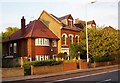
582 & 584 Lordship Lane, London N22
The 1950's style house grafted onto the end of a truncated Victorian terrace is a consequence of the only significant bomb strike on Lordship Lane during World War 2.
Image: © Arb
Taken: 3 Apr 2006
0.12 miles
4
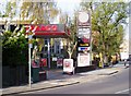
Texaco petrol filling station, Lordship Lane, London N22
The Texaco petrol filling station in Lordship Lane, London N22.
Image: © Arb
Taken: 29 Mar 2006
0.13 miles
5
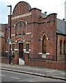
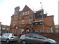
Wood Green : Eldon Road Baptist Church
Built 1935-1936 to a design by architect Frederick George Faunch (1863-1945).
Image: © Jim Osley
Taken: 19 Oct 2021
0.13 miles
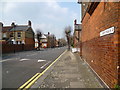
6
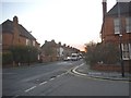
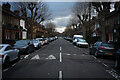
Morley Avenue at the junction of Salisbury Road
Image: © David Howard
Taken: 20 Jan 2016
0.13 miles
8
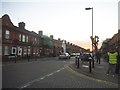
The Noel Park Estate
The Noel Park Estate was built by the Artisan Company between 1881 and 1927. It was specifically designed to provide affordable and fashionable for working class families wishing to leave the inner city. It was designed by Rowland Plumbe and the estate holds some 2,000 properties. Plumbe designed the estate with five different classes of house. Although they vary in size all the houses were designed with front and back gardens. Each of the streets were given their own distinct look.
Noel Park was named after Ernest Noel, Liberal MP and Chairman of the Artisan Company from 1880. The streets were named after board members and people connected to the Artisan Company, as well as prominent politicians of the time - hence Gladstone Avenue and Salisbury Road. Throughout the estate, except for corner houses, each house was built in pairs, with each sharing a porch.
The estate was formally declared open on 4th August 1883 after 200 houses had been completed and another 400 were under construction. A ceremony was held on the site where St Mark's Church now stands. The church was consecrated on 1st November 1889 and by the turn of the 20th century had a congregation twice the size of any other church in Wood Green.
In 1982 in recognition of its architectural and historic interest Noel Park was declared a Conservation Area. This photograph is on the corner of Hewitt Avenue and Salisbury Road.
Image: © Marathon
Taken: 8 Apr 2015
0.15 miles
9
Salisbury Road, Noel Park
The Noel Park Estate was built by the Artisan Company between 1881 and 1927. It was specifically designed to provide affordable and fashionable for working class families wishing to leave the inner city. It was designed by Rowland Plumbe and the estate holds some 2,000 properties. Plumbe designed the estate with five different classes of house. Although they vary in size all the houses were designed with front and back gardens. Each of the streets were given their own distinct look.
Noel Park was named after Ernest Noel, Liberal MP and Chairman of the Artisan Company from 1880. The streets were named after board members and people connected to the Artisan Company, as well as prominent politicians of the time - hence Gladstone Avenue and Salisbury Road. Throughout the estate, except for corner houses, each house was built in pairs, with each sharing a porch.
The estate was formally declared open on 4th August 1883 after 200 houses had been completed and another 400 were under construction. A ceremony was held on the site where St Mark's Church now stands. The church was consecrated on 1st November 1889 and by the turn of the 20th century had a congregation twice the size of any other church in Wood Green.
In 1982 in recognition of its architectural and historic interest Noel Park was declared a Conservation Area. This photograph looks along Salisbury Road towards the junction with Hewitt Avenue.
Image: © Marathon
Taken: 8 Apr 2015
0.15 miles
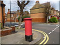
10

Chapmans Green
A small but attractive park in traditional style with bowls and tennis. It holds a Green Flag award.
Text adapted from Wikipedia http://en.wikipedia.org/wiki/Lordship_Lane_%28Haringey%29
Image: © Arb
Taken: 9 Jun 2006
0.16 miles