IMAGES TAKEN NEAR TO
Salisbury Road, LONDON, N22 6NN
Introduction
This page details the photographs taken nearby to Salisbury Road, N22 6NN by members of the Geograph project.
The Geograph project started in 2005 with the aim of publishing, organising and preserving representative images for every square kilometre of Great Britain, Ireland and the Isle of Man.

There are currently over 7.5m images from over14,400 individuals and you can help contribute to the project by visiting https://www.geograph.org.uk
Image Map
Images are licensed for reuse under creativecommons.org/licenses/by-sa/2.0
Notes
- Clicking on the map will re-center to the selected point.
- The higher the marker number, the further away the image location is from the centre of the postcode.
Image Listing (75 Images Found)
Images are licensed for reuse under creativecommons.org/licenses/by-sa/2.0
Image
Details
Distance
1
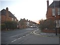
Morley Avenue at the junction of Salisbury Road
Image: © David Howard
Taken: 20 Jan 2016
0.03 miles
2
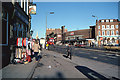
Wood Green (from the late 1970's)
Here's where I used to live in the late 1970's. It's changed rather a lot since then.
Image: © Steven Muster
Taken: 11 Jun 1977
0.05 miles
6

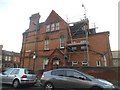
The Freemasons Tavern
Named after the former school whose land it adjoins. Opened c1875. Closed and boarded up autumn 2007.
Image: © Arb
Taken: 3 Feb 2008
0.10 miles
7
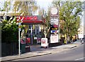
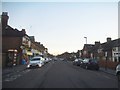
Texaco petrol filling station, Lordship Lane, London N22
The Texaco petrol filling station in Lordship Lane, London N22.
Image: © Arb
Taken: 29 Mar 2006
0.13 miles
8

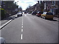
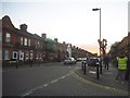
Perth Road at the junction of Dunbar Road
The large building downstairs houses a Paddy Power betting shop
Image: © David Howard
Taken: 20 Jan 2016
0.13 miles
10
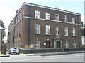
Bowes Park Telephone Exchange (1)
Located at 661 Lordship Lane N22 5LA, this TE would appear to date from the 1930s, a building that the art historian Nikolaus Pevsner would have approved of. It has the code LNBPK and provides telephone and broadband services to 23,227 residential and 1,012 non-residential premises in Bowes Park and Wood Green. Until the late 1960s, it used to have BOWes Park and MULberry numbers. The ornate entrance would appear to be no longer used, the present entrance being to the left of it having originally had window panes like the other three front ones.
Image: © David Hillas
Taken: 8 Jun 2013
0.14 miles