IMAGES TAKEN NEAR TO
N22 4PL
Introduction
This page details the photographs taken nearby to N22 4PL by members of the Geograph project.
The Geograph project started in 2005 with the aim of publishing, organising and preserving representative images for every square kilometre of Great Britain, Ireland and the Isle of Man.

There are currently over 7.5m images from over14,400 individuals and you can help contribute to the project by visiting https://www.geograph.org.uk
Image Map
Images are licensed for reuse under creativecommons.org/licenses/by-sa/2.0
Notes
- Clicking on the map will re-center to the selected point.
- The higher the marker number, the further away the image location is from the centre of the postcode.
Image Listing (149 Images Found)
Images are licensed for reuse under creativecommons.org/licenses/by-sa/2.0
Image
Details
Distance
2
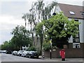
Truro Road / Clarence Road, N22
Shows the location of Image
Image: © Mike Quinn
Taken: 15 Jul 2015
0.04 miles
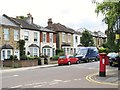
3
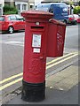
Edward VII postbox, Truro Road / Clarence Road, N22
Image: © Mike Quinn
Taken: 15 Jul 2015
0.05 miles
4
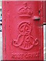
Edward VII postbox, Truro Road / Clarence Road, N22 - royal cipher
See Image
Image: © Mike Quinn
Taken: 15 Jul 2015
0.05 miles
5
Truro Road / Clarence Road, N22 (2)
Shows the location of Image
Image: © Mike Quinn
Taken: 15 Jul 2015
0.05 miles
6
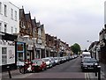
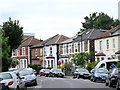
Myddleton Road, Bowes Park
The development of the suburb of Bowes Park began to accelerate when the Great Northern Railway opened a station there in 1880. Myddleton Road, its main shopping street, was photographed from Whittington Road, a few yards from the station.
Image: © David Kemp
Taken: 9 May 2006
0.07 miles
7
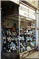
George Moore menswear shop, Bowes Park
In Myddleton Road lies the George Moore menswear shop whose window display has been unchanged since the establishment closed many years ago.
Image: © Jim Osley
Taken: 18 Apr 2011
0.07 miles
8
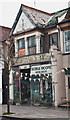
Former menswear shop, Myddleton Road
Since its closure in the 1990s the window displayed remains untouched.
Image: © Jim Osley
Taken: 26 Apr 2014
0.07 miles
9
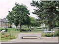
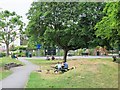
Finsbury Gardens
In the foreground is an example of the work of the Metropolitan Drinking Water Fountain and Cattle Trough Association, which was formed in 1859; it changed its name to include cattle troughs in 1867, to also support animal welfare. For further info, see the Wiki entry https://en.wikipedia.org/wiki/Metropolitan_Drinking_Fountain_and_Cattle_Trough_Association . See also Image
The New River runs beneath these gardens, in a 700 yard long tunnel from north of Myddleton Road, emerging south of Park Avenue Image
Image: © Mike Quinn
Taken: 15 Jul 2015
0.07 miles