IMAGES TAKEN NEAR TO
Hartland Close, LONDON, N21 2BG
Introduction
This page details the photographs taken nearby to Hartland Close, N21 2BG by members of the Geograph project.
The Geograph project started in 2005 with the aim of publishing, organising and preserving representative images for every square kilometre of Great Britain, Ireland and the Isle of Man.

There are currently over 7.5m images from over14,400 individuals and you can help contribute to the project by visiting https://www.geograph.org.uk
Image Map
Images are licensed for reuse under creativecommons.org/licenses/by-sa/2.0
Notes
- Clicking on the map will re-center to the selected point.
- The higher the marker number, the further away the image location is from the centre of the postcode.
Image Listing (126 Images Found)
Images are licensed for reuse under creativecommons.org/licenses/by-sa/2.0
Image
Details
Distance
2
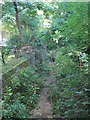
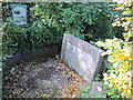
The course of Salmon's Brook west of the Clarendon Arch
The brook must be diverted somewhere to the northwest, as it re-appears from a conduit to the east of the Clarendon Arch - see Image
Image: © Mike Quinn
Taken: 14 Oct 2015
0.07 miles
3
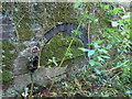
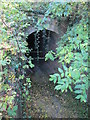
Former conduit by Salmon's Brook west of the Clarendon Arch
Image: © Mike Quinn
Taken: 14 Oct 2015
0.08 miles
4
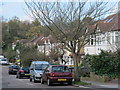
Bush Hill looking north, N21
Bush Hill looking north with the New River on the Right.
Image: © Christine Matthews
Taken: 18 Feb 2007
0.08 miles
5
Plaque and information board above the Clarendon Arch
Image: © Mike Quinn
Taken: 14 Oct 2015
0.08 miles
6
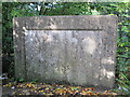
Plaque above the Clarendon Arch
See Image
The inscription on the plaque reads "This Bank of Earth was raised and formed to support the channel of the New River. And the Frame of Timber and Lead which served that purpose 173 years was removed and taken away. MDCCLXXXVI. Peter Holford Esquire Governor".
Image: © Mike Quinn
Taken: 14 Oct 2015
0.08 miles
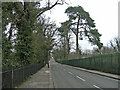
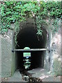
7
The northwestern end of the Clarendon Arch
See Image and Image
The crest and inscription on the arch are obscured by the vegetation - see Image (photographed by John Salmon). The crest is Myddelton's. The inscription on the arch says "This arch was rebuilt in the year 1682. Honerable Henry Earle of Clarendon Being Gov." .
The arch and the tunnel are Grade II listed http://www.britishlistedbuildings.co.uk/en-200558-clarendon-arch-and-tunnel-greater-london .
Image: © Mike Quinn
Taken: 14 Oct 2015
0.08 miles
8
The Clarendon Arch (3)
This photo shows the southeastern end of the arch; a "reverse" view from the northwestern end is shown in Image
Image: © Mike Quinn
Taken: 14 Oct 2015
0.08 miles
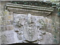
10

Crest and inscription on the Clarendon Arch
See Image
Image: © Mike Quinn
Taken: 2 Dec 2015
0.08 miles