IMAGES TAKEN NEAR TO
Springbank, LONDON, N21 1JH
Introduction
This page details the photographs taken nearby to Springbank, N21 1JH by members of the Geograph project.
The Geograph project started in 2005 with the aim of publishing, organising and preserving representative images for every square kilometre of Great Britain, Ireland and the Isle of Man.

There are currently over 7.5m images from over14,400 individuals and you can help contribute to the project by visiting https://www.geograph.org.uk
Image Map
Images are licensed for reuse under creativecommons.org/licenses/by-sa/2.0
Notes
- Clicking on the map will re-center to the selected point.
- The higher the marker number, the further away the image location is from the centre of the postcode.
Image Listing (84 Images Found)
Images are licensed for reuse under creativecommons.org/licenses/by-sa/2.0
Image
Details
Distance
1
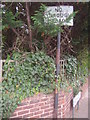
Pre-Worboys no through road sign and pole, Brookside
Image: © David Howard
Taken: 22 Sep 2009
0.04 miles
2
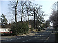
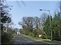
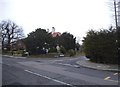
Eversley Park Road looking up hill, Brookside on left.
Looking up Eversley Park Road with the corner of Brookside on the left. This road had originally been called Cock Hill. The Houndsden Gutter passes under the road not far from where the photographer was standing.
Image: © Christine Matthews
Taken: 2 Apr 2007
0.04 miles
3
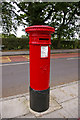
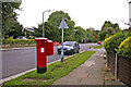
Victorian Pillar Box, Worlds End Lane, London N21
Victorian Pillar box in Worlds End Lane between Highlands Avenue and Tresilian Avenue.
Image: © Christine Matthews
Taken: 26 Aug 2008
0.05 miles
4
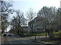
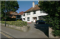
Eversley Park Road with Springbank on the right
Looking up towards the junction where the Winchmore public house (formerly the Chase Side Tavern) is situated, with Springbank on the right.
Image: © Christine Matthews
Taken: 2 Apr 2007
0.05 miles
5
Eversley Park Road looking up the other hill, Brookside on right just out of photograph
Looking up the other hill, the Houndsden Gutter passes under the road where the photographer was standing.
Image: © Christine Matthews
Taken: 2 Apr 2007
0.06 miles
6
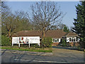
Bungalows, Eversley Park Road, N21
Bungalows on corner of Eversley Park Road and Brookside, which are shortly to be redeveloped.
Image: © Christine Matthews
Taken: 2 Apr 2007
0.07 miles
7
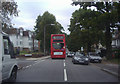
699 bus on Eversley Park Road, Winchmore Hill
Image: © David Howard
Taken: 22 Sep 2009
0.07 miles
8
Eversley Park Road, London N21
Looking down Eversley Park Road from the corner of Holly Hill. George V pillar box Image] can be seen on the left. We are looking towards the valley where the Houndsden Gutter goes under the road.
Image: © Christine Matthews
Taken: 12 Sep 2008
0.08 miles
9
Eversley Park Road at the junction with Eversley Mount
Image: © David Howard
Taken: 27 Mar 2014
0.09 miles
10
The Grange, 48 Eversley Park Road, Winchmore Hill
The onetime home of Alfredo Campoli, an eminent violinist of the 1950s. The grounds of the mansion were sold off to become a select housing development. See Image] for the house in 1958.
Image: © Julian Paren
Taken: 6 Oct 2021
0.10 miles