IMAGES TAKEN NEAR TO
Cecilia Close, LONDON, N2 0UT
Introduction
This page details the photographs taken nearby to Cecilia Close, N2 0UT by members of the Geograph project.
The Geograph project started in 2005 with the aim of publishing, organising and preserving representative images for every square kilometre of Great Britain, Ireland and the Isle of Man.

There are currently over 7.5m images from over14,400 individuals and you can help contribute to the project by visiting https://www.geograph.org.uk
Image Map
Images are licensed for reuse under creativecommons.org/licenses/by-sa/2.0
Notes
- Clicking on the map will re-center to the selected point.
- The higher the marker number, the further away the image location is from the centre of the postcode.
Image Listing (151 Images Found)
Images are licensed for reuse under creativecommons.org/licenses/by-sa/2.0
Image
Details
Distance
1
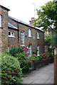
Cottage off Helen Close
Located on a footpath section of the Thomas More estate, This cottage and the adjacent building is part of the original convent on this site, though what its role was I don't know. The bricks are significantly smaller than the modern bricks used to build the new housing estate. There is evidence of a wall extending at rightangles from the right hand end of the building - the area where the bricks were removed can be just made out behind the pink Hydrangea.
Image: © Martin Addison
Taken: 25 Aug 2008
0.01 miles
2
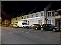
Walking Home
Two teenagers chatting as they walk along Hamilton Road towards East End Road.
Image: © Martin Addison
Taken: 11 Nov 2007
0.04 miles
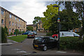
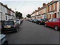
3
Cecilia Close
Part of the Thomas More estate seen here from the junction with Hamilton Road. The usual 'residents parking only' and 'no ball games' signs are on display.
Image: © Martin Addison
Taken: 16 Nov 2007
0.04 miles
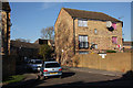
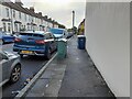
4
Helen Close
Part of the Thomas More estate, built on the site of a convent - see Image for a bit of the history.
Image: © Martin Addison
Taken: 22 Aug 2008
0.05 miles
5
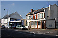
Showroom and Houses
Located on East End Road between Brackenbury Road, on the right, and Hamilton Road. The house on the corner has clearly once been a shop and has been returned to housing. The blue building in the centre is a carpet showroom.
Image: © Martin Addison
Taken: 30 Aug 2008
0.06 miles
8
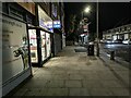
East End Road, East Finchley
These were my nearest shops from 1965-93
Image: © David Howard
Taken: 12 Dec 2020
0.07 miles
9
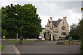
St. Marylebone Cemetery
One of the entrances from East End Road viewed across the car park beside the Thomas More centre. The cemetery is on the former Newmarket farm, which was purchased by the St.Marylebone Burial Board in 1854. There is now also a crematorium on the site, which has its own chapel.
Image: © Martin Addison
Taken: 22 Aug 2008
0.08 miles
10
Myer's carpet warehouse on East End Road
Image: © David Howard
Taken: 19 Dec 2014
0.08 miles