IMAGES TAKEN NEAR TO
The Causeway, LONDON, N2 0PR
Introduction
This page details the photographs taken nearby to The Causeway, N2 0PR by members of the Geograph project.
The Geograph project started in 2005 with the aim of publishing, organising and preserving representative images for every square kilometre of Great Britain, Ireland and the Isle of Man.

There are currently over 7.5m images from over14,400 individuals and you can help contribute to the project by visiting https://www.geograph.org.uk
Image Map
Images are licensed for reuse under creativecommons.org/licenses/by-sa/2.0
Notes
- Clicking on the map will re-center to the selected point.
- The higher the marker number, the further away the image location is from the centre of the postcode.
Image Listing (376 Images Found)
Images are licensed for reuse under creativecommons.org/licenses/by-sa/2.0
Image
Details
Distance
1
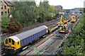
Weekend Line and Station Closures
That's the title of the email notifications sent out every Thursday by Transport for London to advise of planned engineering works. October 5th/6th and 12th/13th would see the High Barnet Branch of the Northern Line closed two weekends in a row for track replacement at Finchley Central and East Finchley. An extensive network of rail replacement buses was provided.
Battery locomotive L54 stands in the turn-round siding at East Finchley with a train of old ballast that has been removed from the northbound running line - L15 is visible at the other end of the train. East Finchley Station is visible in the distance. The discarded track sections were being uploaded to a truck in the station Carpark, which was sealed off for the weekend and given over to staff parking and ancillary vehicles associated with the work.
Image: © Martin Addison
Taken: 12 Oct 2013
0.01 miles
2
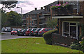
The Causeway
Modern housing backing onto the Northern Line. The purple Smartcar is operated by Home Call, a meals-on-wheels service.
Image: © Martin Addison
Taken: 1 Oct 2008
0.02 miles

4
Deansway
Looking towards the junction with East End Road. The yellow signs warn that East End road is closed to east bound traffic and a diversion is in operation. It's amazing how many drivers still turn right and are surprised to find cones across the road!
Image: © Martin Addison
Taken: 1 Oct 2008
0.04 miles
5
Flats on Cedar Drive
Modern three storey blocks with parking, garages and nice sized balconies. The Geraniums look to be doing well.
Image: © Martin Addison
Taken: 1 Oct 2008
0.05 miles
6

Ordnance Survey Cut Mark
This OS cut mark can be found on the NW parapet of the railway bridge. It marks a point 93.940m above mean sea level.
Image: © Adrian Dust
Taken: 2 Aug 2016
0.05 miles
8
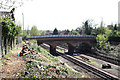
East End Road Bridge
Seen from the bridge carrying Prospect Place over the Northern Line. This view has only been possible since recent work to remove trees from the embankments.
Image: © Martin Addison
Taken: 10 Apr 2011
0.05 miles
9
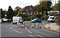
Chaos Ensues
You close a road and it confuses lots of people. The dark blue VW exiting on the left drove right up to the cones before they believed that the road was really closed and then caused pandemonium by reversing back. The junction of East End Road with Deansway on the left.
Image: © Martin Addison
Taken: 1 Oct 2008
0.05 miles