IMAGES TAKEN NEAR TO
High Road, LONDON, N20 9RN
Introduction
This page details the photographs taken nearby to High Road, N20 9RN by members of the Geograph project.
The Geograph project started in 2005 with the aim of publishing, organising and preserving representative images for every square kilometre of Great Britain, Ireland and the Isle of Man.

There are currently over 7.5m images from over14,400 individuals and you can help contribute to the project by visiting https://www.geograph.org.uk
Image Map
Images are licensed for reuse under creativecommons.org/licenses/by-sa/2.0
Notes
- Clicking on the map will re-center to the selected point.
- The higher the marker number, the further away the image location is from the centre of the postcode.
Image Listing (39 Images Found)
Images are licensed for reuse under creativecommons.org/licenses/by-sa/2.0
Image
Details
Distance
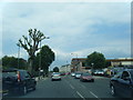
1
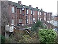
Flats above shops, Whetstone High Road
Two-storey flats on the east side of the A1000, seen from the rear.
Image: © Christine Johnstone
Taken: 6 Jan 2016
0.04 miles
2
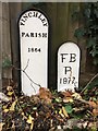
Old Boundary Markers
Parish Boundary Markers in front of a fence on the access road beside Halfords and off the east side of the A1000 High Road. On the former boundary of Finchley and Friern Barnet parishes. MX_BARN03pb in raised lettering FINCHLEY / PARISH 1864 and HE_BARN02pb in recessed lettering F B / P / 1877. See also http://www.geograph.org.uk/photo/4786716.
Milestone Society National ID: HE_BARN02pb on the right and MX_BARN03pb on the left.
Image: © P Winnett
Taken: 23 Nov 2019
0.04 miles
3
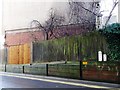
Parish boundary markers, east of Whetstone High Road
Marking the boundary of Finchley Parish in 1864 and Friern Barnet Parish 1877. On a side street that forms the access to the Travelodge hotel and the new Oakwell Grange housing development.
Image: © Christine Johnstone
Taken: 7 Jan 2016
0.04 miles
4
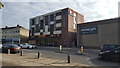
Travelodge Whetstone
The Travelodge at Whetstone, north London.
Image: © Peter Mackenzie
Taken: 10 Sep 2019
0.05 miles
6
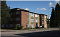
Thatcham Court
A block of flats located on Buckingham Avenue, just off the A1000 in Whetstone.
Image: © Martin Addison
Taken: 5 Sep 2009
0.06 miles
7
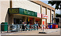
Superstores, Whetstone
The entrances of Marks & Spencer and Carpet Right, seen from the A1000.
Image: © Martin Addison
Taken: 5 Sep 2009
0.07 miles
8
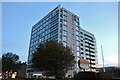
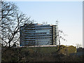
Angle House, Whetstone
This is one of the many large purpose-built office blocks in London recently converted to residential use as the planning constraint was removed. Others are Westworld and Westgate in Ealing and the old Green Shield House in Edgware where long term tenants, some who had been there since it was built, were given six months notice to leave.
Image: © David Howard
Taken: 21 Sep 2019
0.07 miles
9
Northway House
Looking across the warehouses from Brook Farm Playing Fields
Image: © Alasdair Addison
Taken: 6 Dec 2008
0.08 miles
10
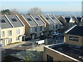
New houses in Well Grove, Whetstone
February 2019, and most houses are finished, but not the community building.
Image: © Christine Johnstone
Taken: 25 Feb 2019
0.08 miles