IMAGES TAKEN NEAR TO
High Road, LONDON, N20 9HP
Introduction
This page details the photographs taken nearby to High Road, N20 9HP by members of the Geograph project.
The Geograph project started in 2005 with the aim of publishing, organising and preserving representative images for every square kilometre of Great Britain, Ireland and the Isle of Man.

There are currently over 7.5m images from over14,400 individuals and you can help contribute to the project by visiting https://www.geograph.org.uk
Image Map (Loading...)


Getting Data...Please wait
Leaflet Map data © OpenStreetMap
Images are licensed for reuse under creativecommons.org/licenses/by-sa/2.0
Notes
- Clicking on the map will re-center to the selected point.
- The higher the marker number, the further away the image location is from the centre of the postcode.
Image Listing (86 Images Found)
Images are licensed for reuse under creativecommons.org/licenses/by-sa/2.0
Image
Details
Distance
1
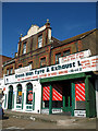
The Green Man
Rebuilt in 1830, the name suggests that this was once a public house and there is a reference to it existing as the Red Lion by 1521. It was catering for waggoners by 1800 and is recorded as having pleasure grounds until the beginning of the 20th century, (information from British History Online). It was converted into a garage and currently carries out services, tyre changes, exhaust and clutch replacements. It used to supply petrol as well and the location of the pumps is still visible as a slightly raised area on the plinth in front of the shop, (just left of centre).
Image: © Martin Addison
Taken: 6 Apr 2007
0.02 miles
2
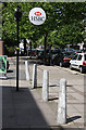
HSBC Whetstone
A number of shops and offices in Whetstone are set further back from the A1000 than the surrounding premises. Here, the HSBC bank advertises its presence. The bollards mark the boundary of its property.
Image: © Martin Addison
Taken: 18 Jul 2009
0.02 miles
4
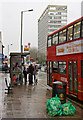
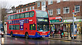
The Bus is Here!
Damp prospective passengers furl their umbrellas and search for their Oyster cards as the southbound 34 bus pulls in on the High Road, Whetstone. Meanwhile another passenger checks the time that her bus is due on the indicator inside the shelter. Another prospective passenger can be seen beyond, risking life and limb, running across the road - it's not a day to miss your bus! The office block behind is Barnet House.
Image: © Martin Addison
Taken: 16 Jan 2010
0.03 miles
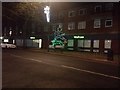
6
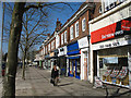
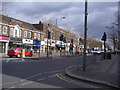
Shops on the High Street, Whetstone
The pedestrian traffic is light on a Maundy Thursday afternoon. The young plane trees will give some shade once they come into leaf.
Image: © Martin Addison
Taken: 6 Apr 2007
0.04 miles
7
All Steamed Up
A 263 bound for Barnet Hospital stops to collect passengers in Whetstone. The rain is tipping down and damp humanity travelling on board has steamed up all the windows.
Image: © Martin Addison
Taken: 16 Jan 2010
0.06 miles
8
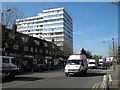
High Street, Whetstone
Looking towards Barnet from the junction with Chandos Avenue. The office block on the opposite side of the road is Northway House. The traffic is, as usual, heavy through Whetstone.
Image: © Martin Addison
Taken: 6 Apr 2007
0.08 miles
9
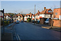
St. Margarets Avenue
This avenue runs from the High Road to Totteridge Lane. It has a sharp left turn at the High Road end, seen here, and an 'S' bend close to the junction with Totteridge Lane. With congestion being a problem on the High Road, this is a popular rat run.
Image: © Martin Addison
Taken: 6 Dec 2008
0.08 miles
10
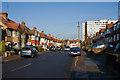
St. Margarets Avenue
The straight section of this popular cut through runs parallel with the High Road. The white office block is Northway House.
Image: © Martin Addison
Taken: 6 Dec 2008
0.09 miles