IMAGES TAKEN NEAR TO
Oakleigh Road North, N20 9FG
Introduction
This page details the photographs taken nearby to Oakleigh Road North, N20 9FG by members of the Geograph project.
The Geograph project started in 2005 with the aim of publishing, organising and preserving representative images for every square kilometre of Great Britain, Ireland and the Isle of Man.

There are currently over 7.5m images from over14,400 individuals and you can help contribute to the project by visiting https://www.geograph.org.uk
Image Map
Images are licensed for reuse under creativecommons.org/licenses/by-sa/2.0
Notes
- Clicking on the map will re-center to the selected point.
- The higher the marker number, the further away the image location is from the centre of the postcode.
Image Listing (48 Images Found)
Images are licensed for reuse under creativecommons.org/licenses/by-sa/2.0
Image
Details
Distance
1
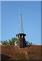
Fleche, Christ Church at Whetstone United Reformed Church, Oakleigh Park
Image: © Jim Osley
Taken: 29 Mar 2014
0.03 miles
2
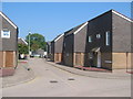
Attfield Close, Whetstone, Barnet
Part of the Sweets Way estate, built c.1970 on land formerly occupied by Sweet's horticultural nursery business.
Image: © John Attfield
Taken: 4 Sep 2005
0.05 miles
3
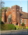
Christ Church at Whetstone United Reformed Church, Oakleigh Park
Built as a Congregational Church in 1900-1901 to the designs of architect Edward Frost Knight. A history of the church may be found at this http://www.christchurchatwhetstoneurc.co.uk/WhestonePDF.pdf.
Image: © Jim Osley
Taken: 29 Mar 2014
0.05 miles
4
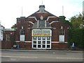
Christ Church at Whetstone
Christ Church at Whetstone on corner of Oakleigh Road North and Oakleigh Park North
Image: © Christine Matthews
Taken: 20 Oct 2005
0.05 miles
5
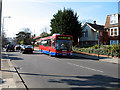
251 on Oakleigh Road
A brand new MCV eVolution bodied MAN bus on the 251 route to Arnos Grove. This was the first week in service for this type on the route.
Image: © Martin Addison
Taken: 6 Apr 2007
0.06 miles
8
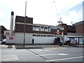
Former postal sorting office, Whetstone, London N20
Image: © Jim Osley
Taken: 8 Aug 2010
0.10 miles
9
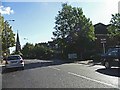
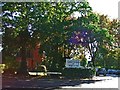
Oakleigh Road North, the A109, looking east
Oakleigh Road North, the A109, looking east towards All Saints Church, Friern Barnet TQ2793
Image: © Christine Matthews
Taken: 20 Oct 2005
0.13 miles
10
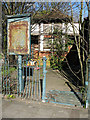
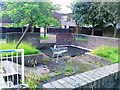
Disused Public Convenience
Opposite the council offices in Barnet House is this neglected piece of civic architecture. It must once have been a symbol of civic pride, finished in a half-timbered style. The trees might come in handy if you need to spend a penny!
Subsequent to this photo being taken, in September 2009 it was noted that these toilets and the adjacent building have been demolished and the site cleared.
Image: © Martin Addison
Taken: 6 Apr 2007
0.15 miles