IMAGES TAKEN NEAR TO
Athenaeum Road, LONDON, N20 9DT
Introduction
This page details the photographs taken nearby to Athenaeum Road, N20 9DT by members of the Geograph project.
The Geograph project started in 2005 with the aim of publishing, organising and preserving representative images for every square kilometre of Great Britain, Ireland and the Isle of Man.

There are currently over 7.5m images from over14,400 individuals and you can help contribute to the project by visiting https://www.geograph.org.uk
Image Map
Images are licensed for reuse under creativecommons.org/licenses/by-sa/2.0
Notes
- Clicking on the map will re-center to the selected point.
- The higher the marker number, the further away the image location is from the centre of the postcode.
Image Listing (35 Images Found)
Images are licensed for reuse under creativecommons.org/licenses/by-sa/2.0
Image
Details
Distance
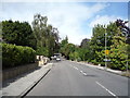
1
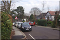
Oakleigh Park North
Oakleigh Park is a name invented by the Whetstone Freehold Estate Company who acquired land here in 1869. It intended to establish a 'superior suburb' and the name was firmly established when the nearby railway station was so named in 1873. Certainly the houses here on Oakleigh Park North are of the superior sort, although in practice much of the area was built up after the estate had been sold.
Image: © Stephen McKay
Taken: 6 Feb 2017
0.05 miles
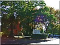
2
Oakleigh Park South
Oakleigh Park is a name invented by a Victorian development company for this area to the east of Whetstone. It has survived largely because the Great Northern Railway used the name for its local station (rather than plain 'Whetstone' as originally intended). The houses here where Oakleigh Avenue meets Oakleigh Park South by a small triangular green are large detached properties.
Image: © Stephen McKay
Taken: 6 Feb 2017
0.15 miles
3
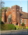
Christ Church at Whetstone United Reformed Church, Oakleigh Park
Built as a Congregational Church in 1900-1901 to the designs of architect Edward Frost Knight. A history of the church may be found at this http://www.christchurchatwhetstoneurc.co.uk/WhestonePDF.pdf.
Image: © Jim Osley
Taken: 29 Mar 2014
0.16 miles
4
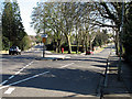
Oakleigh Park
Oakleigh Park South, on the left, and Oakleigh Avenue go their separate ways. Because of the acute nature of the junction, Oakleigh Avenue's road name is displayed at rightangles to the traffic on Oakleigh Park South. The yellow sign reminds drivers of the 30mph speed limit. A modern pillarbox is sited on the v of the junction.
Image: © Martin Addison
Taken: 6 Apr 2007
0.16 miles
5
Christ Church at Whetstone
Christ Church at Whetstone on corner of Oakleigh Road North and Oakleigh Park North
Image: © Christine Matthews
Taken: 20 Oct 2005
0.16 miles
6
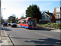
251 on Oakleigh Road
A brand new MCV eVolution bodied MAN bus on the 251 route to Arnos Grove. This was the first week in service for this type on the route.
Image: © Martin Addison
Taken: 6 Apr 2007
0.16 miles
7
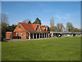
The Pavilion Study Centre
Located in Dame Alice Owens Open Ground, the centre is Barnet's secondary pupil referal unit handling children excluded from normal schools.
Image: © Martin Addison
Taken: 6 Apr 2007
0.17 miles
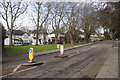
8
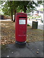
Elizabeth II postbox on Oakleigh Park South N20
Postbox No. N20 2.
Image: © JThomas
Taken: 3 Sep 2016
0.17 miles
10
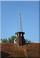
Fleche, Christ Church at Whetstone United Reformed Church, Oakleigh Park
Image: © Jim Osley
Taken: 29 Mar 2014
0.18 miles