IMAGES TAKEN NEAR TO
Buckingham Avenue, LONDON, N20 9DH
Introduction
This page details the photographs taken nearby to Buckingham Avenue, N20 9DH by members of the Geograph project.
The Geograph project started in 2005 with the aim of publishing, organising and preserving representative images for every square kilometre of Great Britain, Ireland and the Isle of Man.

There are currently over 7.5m images from over14,400 individuals and you can help contribute to the project by visiting https://www.geograph.org.uk
Image Map
Images are licensed for reuse under creativecommons.org/licenses/by-sa/2.0
Notes
- Clicking on the map will re-center to the selected point.
- The higher the marker number, the further away the image location is from the centre of the postcode.
Image Listing (58 Images Found)
Images are licensed for reuse under creativecommons.org/licenses/by-sa/2.0
Image
Details
Distance
1
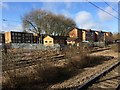
View from a Peterborough-London train - High density housing at Oakeigh Park
Image: © Nigel Thompson
Taken: 7 Feb 2017
0.09 miles
2
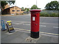
Elizabeth II postbox on Netherlands Road, New Barnet
Postbox No. EN5 222.
Image: © JThomas
Taken: 3 Sep 2016
0.09 miles
3
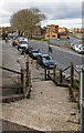
Stairs down to Netherlands Road
Stairs from a footbridge carrying pedestrians across Netherlands Road and the main London to York railway line. The other end of the footpath is on Alverstone Avenue. The paved area and parking bay are outside some shops. The housing to the right of centre is on Stephenson Close. To the right of Stephenson Close is the railway line.
Image: © Martin Addison
Taken: 26 Feb 2010
0.09 miles
4
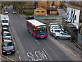
383 on Netherlands Road
A 383 bus on route to Woodside Park Station via Whetstone passes advertising hoardings on Netherlands Road. The bus originated from The Spires in Barnet. It is a short (8.9m) version of the Alexander-Dennis Enviro 200 bus and is operated by Metroline.
The very wet winter has loosened the glue behind the advertisements and the wind is now stripping them away. Behind the bus is Stephenson Close and to the right is the London to York railway line.
Image: © Martin Addison
Taken: 26 Feb 2010
0.10 miles
5
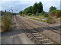
View from the platform at Oakleigh Park station
Looking northwards towards New Barnet, the two middle tracks carry high speed trains, whilst stopping trains use the tracks to the left (mostly hidden by a shrub) and the far right.
The Great Northern Railway opened its line between Maiden Lane and Peterborough through what is now Oakleigh Park in 1850. In 1866 the Whetstone Park Company, promoters of the Whetstone Park Estate, reached an agreement with the Great Northern Railway to construct a new station to serve the development. The station, which was to be known as Whetstone, would open once 25 houses were complete, although the GNR built the two station platforms in anticipation straight away. By summer 1871, the development had been renamed the Oakleigh Park Estate, but not until January 1873 was the developer able to inform the GNR that the 25th house was complete. Accordingly, the GNR authorised the station, now to be known as Oakleigh Park, to be completed. It opened to passenger traffic on 1st December 1873. As part of works to increase the number of tracks from two to four, the station was completely rebuilt in 1891/2 with two island platforms, a new footbridge and booking office.
Image: © Marathon
Taken: 29 Jul 2011
0.10 miles
6
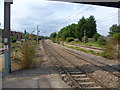
View under a footbridge at Oakleigh Park station
Looking northwards towards New Barnet, the two middle tracks carry high speed trains, whilst stopping trains use the tracks to the left and the right.
The Great Northern Railway opened its line between Maiden Lane and Peterborough through what is now Oakleigh Park in 1850. In 1866 the Whetstone Park Company, promoters of the Whetstone Park Estate, reached an agreement with the Great Northern Railway to construct a new station to serve the development. The station, which was to be known as Whetstone, would open once 25 houses were complete, although the GNR built the two station platforms in anticipation straight away. By summer 1871, the development had been renamed the Oakleigh Park Estate, but not until January 1873 was the developer able to inform the GNR that the 25th house was complete. Accordingly, the GNR authorised the station, now to be known as Oakleigh Park, to be completed. It opened to passenger traffic on 1st December 1873. As part of works to increase the number of tracks from two to four, the station was completely rebuilt in 1891/2 with two island platforms, a new footbridge and booking office.
Image: © Marathon
Taken: 29 Jul 2011
0.11 miles
7
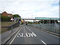
Netherlands Road
Looking north west near Oakleigh Park Railway Station.
Image: © JThomas
Taken: 3 Sep 2016
0.11 miles
8
Oakleigh Park Station Northern Approach
A blue Lumo train heads south past the housing estate on Shurland Avenue to its east. Just above the nose of the train one can see an old concrete and steel lamppost just inside the railway fencing which is all that survives of the infrastructure of a railway marshalling yard that until the early 1960's occupied the land. Vauxhall cars in crates were once brought there by train from the Luton factory for onward transit to the London docks and export. Doubtless it was a costly and inefficient enterprise that is as long gone now as the London docks themselves. One can see the lamppost on photos of the time lighting the start of the sidings. It lingers on without purpose.
Image: © John Kingdon
Taken: 28 Aug 2023
0.11 miles
9
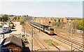
East Coast Main Line just north of Oakleigh Park station, 1991
View northward, towards Hatfield, Hitchin, Peterborough and the North: ex-GNR London end of the ECML, electrified to Hitchin 1976, to Doncaster 1987, to Edinburgh 1991. The Down express streaking away is an IC125 - a DMU, unlike the IC225 EMU shown in the otherwise almost identical scene depicted in Image] by Martin Addison in 2007.
Image: © Ben Brooksbank
Taken: 8 Apr 1995
0.12 miles
10
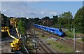
Oakleigh Park
A London bound GNER express approaches Oakleigh Park at speed, having just passed through New Barnet.
Image: © Martin Addison
Taken: 6 Apr 2007
0.12 miles