IMAGES TAKEN NEAR TO
Totteridge Village, LONDON, N20 8NX
Introduction
This page details the photographs taken nearby to Totteridge Village, N20 8NX by members of the Geograph project.
The Geograph project started in 2005 with the aim of publishing, organising and preserving representative images for every square kilometre of Great Britain, Ireland and the Isle of Man.

There are currently over 7.5m images from over14,400 individuals and you can help contribute to the project by visiting https://www.geograph.org.uk
Image Map
Images are licensed for reuse under creativecommons.org/licenses/by-sa/2.0
Notes
- Clicking on the map will re-center to the selected point.
- The higher the marker number, the further away the image location is from the centre of the postcode.
Image Listing (64 Images Found)
Images are licensed for reuse under creativecommons.org/licenses/by-sa/2.0
Image
Details
Distance
1
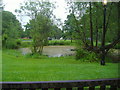
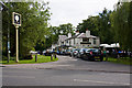
Pond outside Orange Tree pub, Totteridge
Image: © David Howard
Taken: 3 Jun 2008
0.01 miles
2
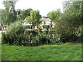
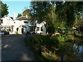
Pond with Orange Tree Public House in background
Village Pond and Public House in Totteridge Lane, Totteridge.
Image: © Christine Matthews
Taken: 28 Sep 2005
0.02 miles
3
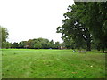
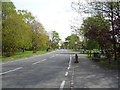
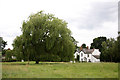
Totteridge Green
Viewed looking towards the A5109 Totteridge Village road.
(From a Geograph point of view this image was taken right on the eastern edge of the grid square with the 525000 Easting line passing approximately through the car on the road. Due to cartographic constraints the Ordnance Survey 1:50,000 scale mapping is a little inaccurate here; the subject and photographer locations have been taken from the more accurate 1:10,000 scale mapping.)
Image: © Nigel Cox
Taken: 8 Sep 2008
0.03 miles
4
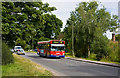
Passing the Orange Tree
DP32 passes the pond beside the Orange Tree public house on the 251 route to Edgware.
Image: © Martin Addison
Taken: 18 Jul 2009
0.03 miles
5
The Orange Tree, Totteridge Village
Seen from the bus stop opposite. A popular location for lunch and parking is always at a premium here.
Image: © Martin Addison
Taken: 18 Jul 2009
0.05 miles
6

The Orange Tree pub and garden, Totteridge
Image: © David Howard
Taken: 25 Jul 2013
0.06 miles
7
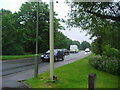
Bus stop on Totteridge Village (A5109)
Looking south east.
Image: © JThomas
Taken: 15 Apr 2017
0.06 miles
8
Totteridge Lane
This part is now called Totteridge Village, as most of the houses only had names they decided rather than add numbers they'd divide the road up instead so people could locate the houses more easily.
Image: © David Howard
Taken: 3 Jun 2008
0.06 miles
9
Orange Tree Pub
Orange Tree Pub in Totteridge lane N20 early in the morning.
Image: © Barnet Walks
Taken: 29 May 2009
0.07 miles
10
Totteridge Village Green
A large open area with a few trees on which a fair is held. Houses are dotted around the boundary.
Image: © Martin Addison
Taken: 18 Jul 2009
0.07 miles