IMAGES TAKEN NEAR TO
Laurel Way, LONDON, N20 8HS
Introduction
This page details the photographs taken nearby to Laurel Way, N20 8HS by members of the Geograph project.
The Geograph project started in 2005 with the aim of publishing, organising and preserving representative images for every square kilometre of Great Britain, Ireland and the Isle of Man.

There are currently over 7.5m images from over14,400 individuals and you can help contribute to the project by visiting https://www.geograph.org.uk
Image Map
Images are licensed for reuse under creativecommons.org/licenses/by-sa/2.0
Notes
- Clicking on the map will re-center to the selected point.
- The higher the marker number, the further away the image location is from the centre of the postcode.
Image Listing (39 Images Found)
Images are licensed for reuse under creativecommons.org/licenses/by-sa/2.0
Image
Details
Distance
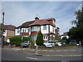
6
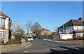
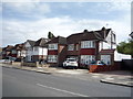
Ventnor Drive, Totteridge
Very similar to Lynton Mead, the next street along. I often wonder if streets were named after where the builders had gone on holiday.
Image: © Des Blenkinsopp
Taken: 26 Feb 2019
0.09 miles
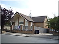
7
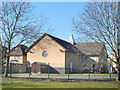
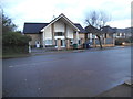
Union Church, Totteridge
A view from the Dollis Valley Greenwalk of the back of the church, which was built in 2001.
The front is shown here Image
Image: © Des Blenkinsopp
Taken: 26 Feb 2019
0.09 miles