IMAGES TAKEN NEAR TO
Naylor Road, LONDON, N20 0HE
Introduction
This page details the photographs taken nearby to Naylor Road, N20 0HE by members of the Geograph project.
The Geograph project started in 2005 with the aim of publishing, organising and preserving representative images for every square kilometre of Great Britain, Ireland and the Isle of Man.

There are currently over 7.5m images from over14,400 individuals and you can help contribute to the project by visiting https://www.geograph.org.uk
Image Map
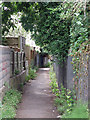
Images are licensed for reuse under creativecommons.org/licenses/by-sa/2.0
Notes
- Clicking on the map will re-center to the selected point.
- The higher the marker number, the further away the image location is from the centre of the postcode.
Image Listing (116 Images Found)
Images are licensed for reuse under creativecommons.org/licenses/by-sa/2.0
Image
Details
Distance
2
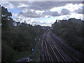
The Northern Line from Totteridge Lane
Heading to Woodside Park and London
Image: © David Howard
Taken: 22 Oct 2008
0.06 miles
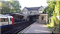
3
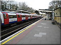
Totteridge & Whetstone Underground station
A northbound Northern Line train for High Barnet awaits departure.
Image: © Nigel Cox
Taken: 1 Apr 2008
0.08 miles
4
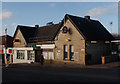
Totteridge and Whetstone Underground Station
"Totteridge & Whetstone station was planned by the Edgware, Highgate and London Railway (EH&LR) and was originally opened as Whetstone and Totteridge on 1 April 1872 by the Great Northern Railway (which had taken over the EH&LR). The station was on a branch line that ran from Finsbury Park to Edgware via Highgate." - quoted from this https://en.wikipedia.org/wiki/Totteridge_%26_Whetstone_tube_station.
Image: © Jim Osley
Taken: 31 Dec 2015
0.08 miles
6
Totteridge and Whetstone underground station
Image: © David Howard
Taken: 16 Jan 2008
0.09 miles
7
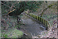
Dollis Brook
Seen here as it passes through Whetstone Stray. The wooden boards help to prevent further erosion of the bank.
Image: © Martin Addison
Taken: 20 Feb 2009
0.10 miles
8
Totteridge & Whetstone station
Opened by the GNR as Whetstone & Totteridge (why was it reversed?), it has a pleasantly subdued style. It is now on the Northern Line.
Image: © Robin Webster
Taken: 25 Nov 2012
0.10 miles
9

Totteridge & Whetstone Station
With a name more reminiscent of a country railway closed in the Beeching era than the Northern Line, this station stands on Totteridge Lane, the road connecting Whetstone with Totteridge. It was opened by the Great Northern Railway in 1872 (originally as Whetstone & Totteridge) and became a constituent part of the London Underground network in 1940.
Image: © Stephen McKay
Taken: 6 Feb 2017
0.10 miles
10
Totteridge and Whetstone station
This underground station is on the northern line near to its terminus at High Barnet.
Image: © Peter Mackenzie
Taken: 12 Sep 2017
0.10 miles