IMAGES TAKEN NEAR TO
Chill Lane, LONDON, N1C 4DS
Introduction
This page details the photographs taken nearby to Chill Lane, N1C 4DS by members of the Geograph project.
The Geograph project started in 2005 with the aim of publishing, organising and preserving representative images for every square kilometre of Great Britain, Ireland and the Isle of Man.

There are currently over 7.5m images from over14,400 individuals and you can help contribute to the project by visiting https://www.geograph.org.uk
Image Map
Images are licensed for reuse under creativecommons.org/licenses/by-sa/2.0
Notes
- Clicking on the map will re-center to the selected point.
- The higher the marker number, the further away the image location is from the centre of the postcode.
Image Listing (568 Images Found)
Images are licensed for reuse under creativecommons.org/licenses/by-sa/2.0
Image
Details
Distance
1
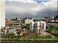
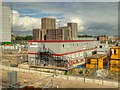
Canal Reach Building Site, King's Cross
Image: © David Dixon
Taken: 29 May 2015
0.02 miles
2
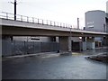
Channel Tunnel Rail Link Works, King's Cross
This shows the alignment of the Channel Tunnel Rail Link at the point where it curves round into St Pancras station, which is now at an advanced stage of construction. This area has changed radically in recent years, the old railway sidings that used to occupy the land have now disappeared, and York Way (from where the picture was taken) follows a new sweeping curve under the rail link.
Image: © Stephen McKay
Taken: 13 Sep 2006
0.03 miles
3
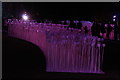
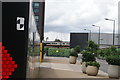
View of Rami Bebawi/KANVA's "Entre Les Rangs" in Lewis Cubitt Park
"Entre Les Rangs" is an illuminated maze of ceramic flowers which the public can walk through via means of a series of walkways. Looking north-northwest.
Image: © Robert Lamb
Taken: 19 Jan 2018
0.05 miles
4
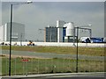
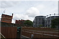
Hanson Ready Mix Concrete site near St Pancras station
Image: © Roy Hughes
Taken: 16 Sep 2023
0.06 miles
5
Urban Redevelopment near King's Cross/St Pancras
Image: © David Dixon
Taken: 29 May 2015
0.06 miles
6
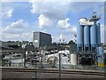
NLL Incline, CTRL and industrial works
In the foreground is the North London Line (NLL) Incline which connects the NLL with the East Coast Main Line (ECML), in the background the NLL-CTRL (Channel Tunnel Rail Link) connection crosses over the St Pancras - ECML connection and the CTRL from St Pancras.
Image: © Timothy Baldwin
Taken: 4 Nov 2006
0.07 miles
7
View of a Class 373 Eurostar crossing Handyside Street
Looking north-northwest.
Image: © Robert Lamb
Taken: 22 Jul 2017
0.08 miles
8

High Speed lines just north of St. Pancras
Image: © Andrew Abbott
Taken: 27 Jul 2010
0.08 miles
9
View of flats near Gasholder Park from Camley Street
Looking north-northeast.
Image: © Robert Lamb
Taken: 22 Jul 2017
0.08 miles
10
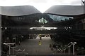
View of Coal Drops Yard from Handyside Street
Looking south-southeast.
Image: © Robert Lamb
Taken: 12 Sep 2020
0.08 miles