IMAGES TAKEN NEAR TO
Bravingtons Walk, LONDON, N1 9GA
Introduction
This page details the photographs taken nearby to Bravingtons Walk, N1 9GA by members of the Geograph project.
The Geograph project started in 2005 with the aim of publishing, organising and preserving representative images for every square kilometre of Great Britain, Ireland and the Isle of Man.

There are currently over 7.5m images from over14,400 individuals and you can help contribute to the project by visiting https://www.geograph.org.uk
Image Map
Images are licensed for reuse under creativecommons.org/licenses/by-sa/2.0
Notes
- Clicking on the map will re-center to the selected point.
- The higher the marker number, the further away the image location is from the centre of the postcode.
Image Listing (2589 Images Found)
Images are licensed for reuse under creativecommons.org/licenses/by-sa/2.0
Image
Details
Distance
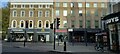
2
Euston Road NW1 and King's Cross Station
Taken from the steps to St Pancras Station, Pancras Road NW1
Image: © Robin Sones
Taken: 15 Sep 2008
0.02 miles
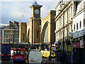
3
Sunset at Kings Cross
Kings Cross Station on the left , traffic wait at the lights heading west along towards the Euston Road. The final rays of sunlight highlight the buildings east of the station.
Image: © roger geach
Taken: 28 Oct 2008
0.02 miles
4
View from McDonald's York Way
View of Euston Road from the first floor of Image The 1970s flat roofed extension to Kings Cross station is due to be removed in the current refurbishment program, once this happens the area should have a more open feel
Image: © Oxyman
Taken: 15 Dec 2008
0.02 miles
5
London, King's Cross
Right outside King's Cross station, on the left out of shot. Two London boroughs meet, Camden & Islington and 3 postal districts, N1, NW1 & WC1 all in this picture. A very busy road junction Euston Road meets Birkenhead Street (on extreme right), Gray's Inn Road (right), Pentonville Road (ahead) and York Way out of shot on the left. According to the square boundaries, the roads to the right of the barrier are in the next square to the south.
Image: © Phillip Perry
Taken: 4 Sep 2010
0.02 miles
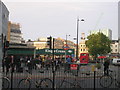
6
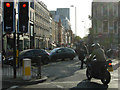
King's Cross traffic
A motorcyclist waits at the busy junction where Euston Road, Pentonville Road, Grays Inn Road and York Way all meet. The morning is sunny and the rush hour traffic, being August, is lighter than it would be at other times of year.
Image: © Stephen McKay
Taken: 28 Aug 2009
0.02 miles
7
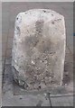
Old Milestone by the A5200, Gray's Inn Road, St Pancras Parish
Carved stone post by the A5200, in parish of St Pancras (CAMDEN District), Gray's Inn Road, by No. 343, adjacent to Kings Cross Police Office, between Birkenhead Street and Argyll Square, by Kings Cross Station, on pavement by traffic lights. Erected by the Marylebone to Finchley Road turnpike trust in the 19th century.
Inscription reads:- : IV / Miles / from Saint / Giles Pound :
Milestone Society National ID: MX_L04.
Image: © JR Dowding & C Woodward
Taken: 8 Mar 2005
0.02 miles
8
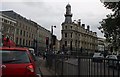
The King's Cross Lighthouse
Recently restored Victorian building in the apex of the junction of Gray's Inn Road and Pentonville Road. The origin of the lighthouse style turret is not known and a variety of suggestions can be found on the internet.
Image: © Martin Addison
Taken: 8 Mar 2017
0.02 miles
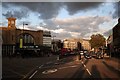
9
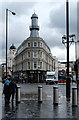
Grays Inn Road, King's Cross
Traffic is always chaotic here at the northern end of Grays Inn Road where vehicles from Caledonian Road, Pentonville Road and Grays Inn Road itself converge on King's Cross station before heading via Euston Road or York Way. The frontage of the station is straight ahead, with the Great Northern Hotel (which has been closed for some years) to the left of that.
Image: © Stephen McKay
Taken: 4 Feb 2008
0.02 miles
10
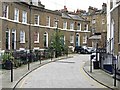
Keystone Crescent, King's Cross
Tucked away off Caledonian Road, this 19th century crescent is a conservation area. A 3-bedroom house here is currently on the market for over £500,000.
Image: © Stephen McKay
Taken: 26 Jun 2006
0.02 miles