IMAGES TAKEN NEAR TO
Noahs Yard, LONDON, N1 9FJ
Introduction
This page details the photographs taken nearby to Noahs Yard, N1 9FJ by members of the Geograph project.
The Geograph project started in 2005 with the aim of publishing, organising and preserving representative images for every square kilometre of Great Britain, Ireland and the Isle of Man.

There are currently over 7.5m images from over14,400 individuals and you can help contribute to the project by visiting https://www.geograph.org.uk
Image Map
Images are licensed for reuse under creativecommons.org/licenses/by-sa/2.0
Notes
- Clicking on the map will re-center to the selected point.
- The higher the marker number, the further away the image location is from the centre of the postcode.
Image Listing (2626 Images Found)
Images are licensed for reuse under creativecommons.org/licenses/by-sa/2.0
Image
Details
Distance
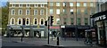
2
Sunset at Kings Cross
Kings Cross Station on the left , traffic wait at the lights heading west along towards the Euston Road. The final rays of sunlight highlight the buildings east of the station.
Image: © roger geach
Taken: 28 Oct 2008
0.01 miles
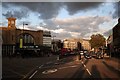
3
View from McDonald's York Way
View of Euston Road from the first floor of Image The 1970s flat roofed extension to Kings Cross station is due to be removed in the current refurbishment program, once this happens the area should have a more open feel
Image: © Oxyman
Taken: 15 Dec 2008
0.01 miles
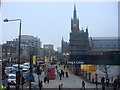
4
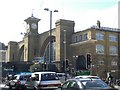
London, King's Cross
Right outside King's Cross station, on the left out of shot. Two London boroughs meet, Camden & Islington and 3 postal districts, N1, NW1 & WC1 all in this picture. A very busy road junction Euston Road meets Birkenhead Street (on extreme right), Gray's Inn Road (right), Pentonville Road (ahead) and York Way out of shot on the left. According to the square boundaries, the roads to the right of the barrier are in the next square to the south.
Image: © Phillip Perry
Taken: 4 Sep 2010
0.01 miles
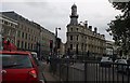
5
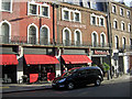
York Way, King's Cross
York Way runs along the eastern side of King's Cross station. Compare this view with Image from 2006 to see how the street has changed; then there was a row of scruffy boarded up shops, now there is a branch of Nandos, a restaurant chain.
Image: © Stephen McKay
Taken: 15 Nov 2013
0.01 miles
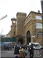
7
King's Cross Railway Station, Euston Road NW1
At the junction with York Way N1
Image: © Robin Sones
Taken: 14 Jul 2009
0.02 miles
9
King's Cross Station, York Way N1
At the junction with Euston Road N1. Taken from Pentonville Road N1
Image: © Robin Sones
Taken: 30 Sep 2009
0.02 miles
10
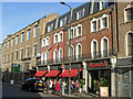
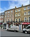
York Way, King's Cross
York Way runs along the eastern side of King's Cross station. It is now much smarter than it used to be with , in this view, a Nando's restaurant that has replaced a row of seedy shops: see Image
Image: © Stephen McKay
Taken: 15 Nov 2013
0.02 miles