IMAGES TAKEN NEAR TO
Ward Road, LONDON, N19 5ED
Introduction
This page details the photographs taken nearby to Ward Road, N19 5ED by members of the Geograph project.
The Geograph project started in 2005 with the aim of publishing, organising and preserving representative images for every square kilometre of Great Britain, Ireland and the Isle of Man.

There are currently over 7.5m images from over14,400 individuals and you can help contribute to the project by visiting https://www.geograph.org.uk
Image Map
Images are licensed for reuse under creativecommons.org/licenses/by-sa/2.0
Notes
- Clicking on the map will re-center to the selected point.
- The higher the marker number, the further away the image location is from the centre of the postcode.
Image Listing (166 Images Found)
Images are licensed for reuse under creativecommons.org/licenses/by-sa/2.0
Image
Details
Distance
1
Northward on A400 Junction Road at bridge over Tottenham & Hampstead Railway, 2006
The namesake station was on the left here, but closed 3/5/43. The Tottenham & Hampstead line was Joint GER & Midland, forming with the Tottenham & Forest Gate an important artery across North London from the Midland at Kentish Town and Carlton Road Junction to Barking and the Tilbury Line. Nowadays the Gospel Oak - Barking service of London Overground passes along here.
Image: © Ben Brooksbank
Taken: 30 Oct 2000
0.04 miles
3
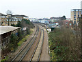
Tottenham and Hampstead line east of Junction Road
In the foreground was the site of Junction Road station, with no obvious traces left. It closed in 1943. The road to the right is called Station Road.
Image: © Robin Webster
Taken: 29 Jan 2011
0.04 miles
4
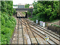
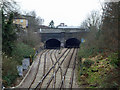
Junction Road Junction
This railway location takes its name from Junction Road which crosses the bridge in the picture. The line from the right is a freight only connection from the Midland Main Line, which joins the Tottenham & Hampstead Line here. There is a passenger service between Gospel Oak and Barking.
Image: © Stephen McKay
Taken: 22 Jul 2008
0.05 miles
6
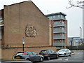
Block of flats with relief mural
The three storey flats appear to be accessed from the front - Junction Road - for the ground floor, and from the back for the upper floors. The end wall facing Wyndham Crescent features a relief mural of perplexing symbolism. It has cavorting naked people of various ages, fishes, water, horses, spoked wheels, vegetation and one bird, possibly a dove.
Image: © Robin Webster
Taken: 29 Jan 2011
0.05 miles
7
Junction Road Junction
The lines to Gospel Oak go right, to the northbound Midland main line to the left. Formerly it was possible to go left and left again later to reach Kentish Town and St Pancras, but that connection has been removed.
Image: © Robin Webster
Taken: 29 Jan 2011
0.05 miles
8
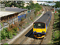
Railway at Upper Holloway
A Barking - Gospel Oak train having left Upper Holloway station runs the short distance to its terminus at Gospel Oak where it will connect with the North London line. This line, known as the Tottenham and Hampstead to railway people, is an important cross-London freight route.
Image: © Stephen McKay
Taken: 4 Sep 2007
0.06 miles