IMAGES TAKEN NEAR TO
Sterling Way, LONDON, N18 2XZ
Introduction
This page details the photographs taken nearby to Sterling Way, N18 2XZ by members of the Geograph project.
The Geograph project started in 2005 with the aim of publishing, organising and preserving representative images for every square kilometre of Great Britain, Ireland and the Isle of Man.

There are currently over 7.5m images from over14,400 individuals and you can help contribute to the project by visiting https://www.geograph.org.uk
Image Map
Images are licensed for reuse under creativecommons.org/licenses/by-sa/2.0
Notes
- Clicking on the map will re-center to the selected point.
- The higher the marker number, the further away the image location is from the centre of the postcode.
Image Listing (37 Images Found)
Images are licensed for reuse under creativecommons.org/licenses/by-sa/2.0
Image
Details
Distance
1
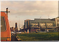
Fore Street at the junction of the North Circular Road, 1989
The building has long since been demolished to alter the route of the road.
Image: © David Howard
Taken: Unknown
0.06 miles
2
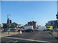
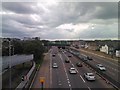
Fore Street at the junction of the North Circular Road
For at least the third time today there was an accident and associated road closure on or around the North Circular east of London, this time a few miles to the east around the Crooked Billet, and the westbound traffic went as far as Finchley. Luckily I was going in the other direction.
Image: © David Howard
Taken: 18 Jul 2013
0.06 miles
3
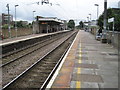
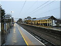
Silver Street railway station, Greater London
Opened in 1872 by the Great Eastern Railway on its line from London Liverpool Street to Broxbourne. View south towards White Hart Lane and London.
Image: © Nigel Thompson
Taken: 3 Jul 2012
0.06 miles
4
Silver Street station, Down platform
View SW from an Up train on the ex-GER Enfield Town - Liverpool Street suburban line (electrified 1960): a lonely (?) person waits for a Down train.
Image: © Ben Brooksbank
Taken: 3 Aug 2007
0.06 miles
6
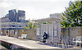
Silver Street station, Edmonton
Silver Street railway station, photographed on a dull and wet December afternoon. The station is served by London Overground suburban trains, on the line from London Liverpool Street to Enfield Town and Cheshunt. The railway is electrified using overhead wires.
Image: © Malc McDonald
Taken: 11 Dec 2021
0.07 miles
9
View of the Fore Street junction from the footbridge over the A406
Looking north-northwest.
Image: © Robert Lamb
Taken: 17 Jun 2012
0.08 miles
10
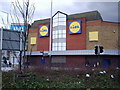
Former site of Regal Cinema
The photograph has been taken at the Angel Edmonton and shows the hideous facade of the supermarket that has now replaced the once Grand 'Regal Cinema' at Upper Edmonton. It demonstrates how many of our historic and dearly loved buildings have been demolished in the face of so called progress. One wonders how the planners could have approved the construction of this building which is a very poor substitute for the previous edifice.
Image: © Alan Swain
Taken: 9 Mar 2008
0.08 miles