IMAGES TAKEN NEAR TO
Ashley Road, LONDON, N17 9AZ
Introduction
This page details the photographs taken nearby to Ashley Road, N17 9AZ by members of the Geograph project.
The Geograph project started in 2005 with the aim of publishing, organising and preserving representative images for every square kilometre of Great Britain, Ireland and the Isle of Man.

There are currently over 7.5m images from over14,400 individuals and you can help contribute to the project by visiting https://www.geograph.org.uk
Image Map
Images are licensed for reuse under creativecommons.org/licenses/by-sa/2.0
Notes
- Clicking on the map will re-center to the selected point.
- The higher the marker number, the further away the image location is from the centre of the postcode.
Image Listing (24 Images Found)
Images are licensed for reuse under creativecommons.org/licenses/by-sa/2.0
Image
Details
Distance
1
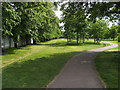
Down Lane Recreation Ground
Down Lane Recreation Ground path from Park View Road heading to Ashley Road
Image: © Shaun Ferguson
Taken: 11 May 2009
0.02 miles
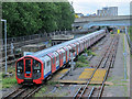
2
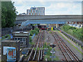
Victoria Line tracks south of the Northumberland Park Depot
Looking towards the footbridge and the Watermead Way overpass shown in Image Photo taken from the footbridge shown in Image
See also Image and Image
Image: © Mike Quinn
Taken: 7 Jun 2017
0.09 miles

4
Victoria Line tracks south of the Northumberland Park Depot (2)
Image: © Mike Quinn
Taken: 7 Jun 2017
0.10 miles
5
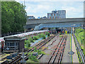
Underpasses: Watermead Way, N17, and railway lines
Looking underneath Watermead Way towards the footbridge over, and the underpass beneath, the railway lines beyond. A Victoria Line train can be seen passing on its way to the Northumberland Park Depot - see Image
Warnings for the unwary: the footbridge is closed off (and appears to have been so for some time). And the railway underpass is impassable as it's flooded to well above ankle height - and there's overwhelming smell of sewage.
Image: © Mike Quinn
Taken: 7 Jun 2017
0.10 miles
6
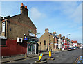
Havelock Road, Tottenham
Part of a quite extensive area of Victorian terrace housing. The shop is Thackeray Mini Market on the corner of Thackeray Avenue.
Image: © Des Blenkinsopp
Taken: 16 Feb 2017
0.10 miles
7
Victoria Line train south of the Northumberland Park Depot (2)
Image: © Mike Quinn
Taken: 7 Jun 2017
0.12 miles
8
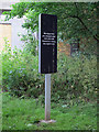
Faux-anthropomorphic sign, Tottenham Marshes
Image: © Mike Quinn
Taken: 7 Jun 2017
0.13 miles
9
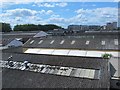
Industrial roofscape by Watermead Way, N17
Image: © Mike Quinn
Taken: 7 Jun 2017
0.14 miles