IMAGES TAKEN NEAR TO
Lordship Lane, LONDON, N17 8NS
Introduction
This page details the photographs taken nearby to Lordship Lane, N17 8NS by members of the Geograph project.
The Geograph project started in 2005 with the aim of publishing, organising and preserving representative images for every square kilometre of Great Britain, Ireland and the Isle of Man.

There are currently over 7.5m images from over14,400 individuals and you can help contribute to the project by visiting https://www.geograph.org.uk
Image Map
Images are licensed for reuse under creativecommons.org/licenses/by-sa/2.0
Notes
- Clicking on the map will re-center to the selected point.
- The higher the marker number, the further away the image location is from the centre of the postcode.
Image Listing (111 Images Found)
Images are licensed for reuse under creativecommons.org/licenses/by-sa/2.0
Image
Details
Distance
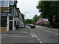
1

Lordship Lane N17 (1)
Near junction of Newlyn Road. Looking the opposite direction to this one http://www.geograph.org.uk/photo/189408
Image: © Danny P Robinson
Taken: 18 Jun 2006
0.03 miles
2
Lordship Lane N17 (2)
Near junction of Newlyn Road, looking the opposite direction to this one http://www.geograph.org.uk/photo/189397
Image: © Danny P Robinson
Taken: 18 Jun 2006
0.05 miles
3

Enfield Magistrates Court
The Probation Service is housed in a modern building on the same site.
Image: © Arb
Taken: 14 May 2006
0.06 miles
4

Bruce Terrace (built 1826)
Grade II listed housing terrace, described briefly at this https://historicengland.org.uk/listing/the-list/list-entry/1079217 .
Image: © Jim Osley
Taken: 5 May 2014
0.06 miles
5
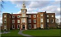
Bruce Castle, Lordship Lane, Tottenham
Originally built in the 16th century as a manor house, and since much altered, Bruce Castle is now serves as a museum housing the archives of the London Borough of Haringey, with a small permanent exhibition relating to Rowland Hill and the history of the postal service. The building is located in Bruce Castle Park, Tottenham's first public park opened in 1892.
Image: © Jim Osley
Taken: 1 Mar 2007
0.08 miles
6

Former London Co-operative Society department store, Tottenham
This white building, complete with classical corner turret, dates from 1930; it stands at the junction between Tottenham High Road, and Lansdowne Road, and until August was home to a well-known chain of carpet retailer.
On the night of 6 August 2011, Tottenham High Road suffered a serious riot, resulting in such damage to this building by fire, that demolition is inevitable. http://www.tottenhamjournal.co.uk/news/tottenham_riots_haringey_starts_to_count_10million_cost_1_988212
Image: © Jim Osley
Taken: 9 Dec 2010
0.08 miles
7
Tottenham Magistrates' Court
Fine example of the neo-Georgian style adopted for so many inter-war public buildings. Designed by W.T. Curtis, Middlesex County Architect, the building is Grade II listed, and described in further detail at this http://www.britishlistedbuildings.co.uk/en-491094-tottenham-magistrates-court-greater-lond
Image: © Jim Osley
Taken: 3 Jun 2013
0.09 miles
8

Millicent Fawcett Court
A small, award-winning deck access council estate, built 1969-70 comprising three blocks arranged as an elongated "u", the long axis running north-south, about four stories high. Named after Millicent Fawcett, suffragist and early feminist. The eastern part of the estate is built over the Moselle River, which was re-culverted during construction of the estate. There have been buildings on this site since at least 1619.
Text adapted from Wikipedia http://en.wikipedia.org/wiki/Lordship_Lane,_Haringey
Image: © Arb
Taken: 8 Jun 2006
0.10 miles
9

Drapers' Almshouses, Bruce Grove, Tottenham
Built 1868-1869 to the designs of the company's architect, Herbert Williams. See also Image
Image: © Jim Osley
Taken: 1 Mar 2007
0.11 miles
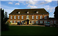
10
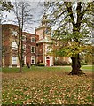
Bruce Castle, Tottenham - elevation to Lordship Lane
Grade I listed building, home to the archives of the London Borough of Haringey and a permanent collection of artefacts relating to the Borough. Architectural description at this https://historicengland.org.uk/listing/the-list/list-entry/1358861.
Image: © Jim Osley
Taken: 8 Nov 2016
0.11 miles