IMAGES TAKEN NEAR TO
Higham Road, LONDON, N17 6NR
Introduction
This page details the photographs taken nearby to Higham Road, N17 6NR by members of the Geograph project.
The Geograph project started in 2005 with the aim of publishing, organising and preserving representative images for every square kilometre of Great Britain, Ireland and the Isle of Man.

There are currently over 7.5m images from over14,400 individuals and you can help contribute to the project by visiting https://www.geograph.org.uk
Image Map
Images are licensed for reuse under creativecommons.org/licenses/by-sa/2.0
Notes
- Clicking on the map will re-center to the selected point.
- The higher the marker number, the further away the image location is from the centre of the postcode.
Image Listing (48 Images Found)
Images are licensed for reuse under creativecommons.org/licenses/by-sa/2.0
Image
Details
Distance
1
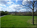
View from Lordship Recreation Ground
Lordship Recreation Ground was first opened as a public park in 1932 on about 100 acres of the former Broadwater Farm which had been acquired by Tottenham Urban District Council. In the intervening years it has reduced in size as the edges have been taken for development, especially for the Broadwater Farm estate built in the early 1970s. The River Moselle runs through the centre of the park from west to east. The river was diverted to the north of its old course as part of substantial investment in Lordship Recreation Ground. More about Lordship Recreation Ground and what the investment over the last ten years has achieved can be seen at http://www.haringey.gov.uk/community-and-leisure/parks-and-open-spaces/z-parks-and-open-spaces/lordship-recreation-ground
This view is near the southern part of the park which is higher than the rest and provides quite wide views, in this case towards Alexandra Palace on the horizon towards the left of the picture.
Image: © Marathon
Taken: 31 Mar 2015
0.08 miles
2
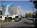
Tottenham: The Broadwater Farm Estate, N17
The estate was built between 1967 and 1973 in a style designed by Le Corbusier where no dwellings were at ground level because of the high water table of the Moselle River which is culverted under the estate. The warren of first floor concrete walkways offered opportunities for crime and anti-social behaviour and the consequent bad reputation of the estate long before the riot of 6 October 1985 which resulted in the murder of PC Keith Blakelock. Further information on the history of the estate can be found on Haringey Council's website here http://www.haringey.gov.uk/index/community_and_leisure/neighbourhoods/broadwaterfarm/historyofbroadwaterfarm.htm This is the Gloucester Road entrance to the estate. The mural on the end wall depicts a waterfall. I don't know if this is an image of an actual place or an idealized depiction of an idyllic rural scene. See Image for another photo of the estate in an adjacent grid square.
Image: © Nigel Cox
Taken: 6 Sep 2006
0.09 miles
3
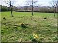
Daffodils at Lordship Recreation Ground
Lordship Recreation Ground was first opened as a public park in 1932 on about 100 acres of the former Broadwater Farm which had been acquired by Tottenham Urban District Council. In the intervening years it has reduced in size as the edges have been taken for development, especially for the Broadwater Farm estate built in the early 1970s. The River Moselle runs through the centre of the park from west to east. The river was diverted to the north of its old course as part of substantial investment in Lordship Recreation Ground. More about Lordship Recreation Ground and what the investment over the last ten years has achieved can be seen at http://www.haringey.gov.uk/community-and-leisure/parks-and-open-spaces/z-parks-and-open-spaces/lordship-recreation-ground
This view is near the southern part of the park which is higher than the rest and provides quite wide views.
Image: © Marathon
Taken: 31 Mar 2015
0.10 miles
5
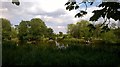
Lordship Lane Rec lake
Reminiscent of a Constable study of the Essex or Suffolk countryside this is in fact in the heart of Tottenham in the London Borough of Haringey. The tower blocks of the Broadwater Farm estate are just out of sight to the left of the picture. It was in covid 19 lockdown so no planes in the sky and few people out.
Image: © John Kingdon
Taken: 9 Jun 2020
0.17 miles
6
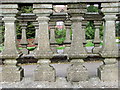
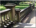
Balustrade
Possibly part of the formal area of Downhills Park House
Image: © Christine Westerback
Taken: 13 Apr 2012
0.17 miles
7
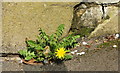
Dandelions grow Anywhere
From the bottom of the balustrade
Image: © Christine Westerback
Taken: 13 Apr 2012
0.17 miles
8
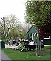
Downhills Park Community Cafe
I had quiche and coffee at this little cafe which supports people with learning disabilities. It is run by volunteers and offers ethically and seasonally sources food - and very nice it was
Image: © Christine Westerback
Taken: 13 Apr 2012
0.17 miles
9

Tottenham: Lordship Recreation Ground
The two distant tower blocks are on the Broadwater Farm Estate and The Moselle river flows parallel to the path and beyond the trees to the right.
Image: © Nigel Cox
Taken: 6 Sep 2006
0.17 miles
10
Balustrade
This looks like part of a formal walkway of the original house
Image: © Christine Westerback
Taken: 13 Apr 2012
0.18 miles