IMAGES TAKEN NEAR TO
Chart Street, LONDON, N1 6DB
Introduction
This page details the photographs taken nearby to Chart Street, N1 6DB by members of the Geograph project.
The Geograph project started in 2005 with the aim of publishing, organising and preserving representative images for every square kilometre of Great Britain, Ireland and the Isle of Man.

There are currently over 7.5m images from over14,400 individuals and you can help contribute to the project by visiting https://www.geograph.org.uk
Image Map
Images are licensed for reuse under creativecommons.org/licenses/by-sa/2.0
Notes
- Clicking on the map will re-center to the selected point.
- The higher the marker number, the further away the image location is from the centre of the postcode.
Image Listing (578 Images Found)
Images are licensed for reuse under creativecommons.org/licenses/by-sa/2.0
Image
Details
Distance
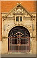
1
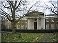
Haberdashers' Aske's almshouses
Along Pitfield Street in Hoxton is this magnificent building which was built by the Haberdashers' Aske's Livery Company. Robert Aske, a Master of the Company in the 18th century, established a foundation to finance the building of Almshouses within a mile of the City of London. By the early 19th century however, the houses were collapsing so they were demolished and a school was erected in 1825. Today, the Haberdashers' Aske's schools are in Hertfordshire and this fine structure has been converted into apartments.
Image: © David Williams
Taken: 22 Nov 2010
0.02 miles
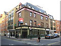
2

Hoxton: The Prince Arthur public house
Surrounded by larger modern buildings, this Shepherd Neame outlet is in Brunswick Place.
Image: © Nigel Cox
Taken: 25 Sep 2008
0.03 miles
3
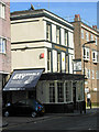
The Prince Arthur, Shoreditch
This pub, tucked away on Brunswick Place just off Old Street, is owned by Shepherd Neame, the Kent brewer.
Image: © Stephen McKay
Taken: 7 Mar 2014
0.04 miles
6
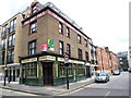
Hoxton: The former Hop Pole public house
This former Truman Hanbury Buxton outlet is in Pitfield Street at its junction with Coronet Street. A specialist website listing closed pubs in London describes it as having been closed before 1985 and lying derelict since, which is remarkable when its external condition is considered. Were it not for the estate agents' signs, you would think it was up and running.
Image: © Nigel Cox
Taken: 25 Sep 2008
0.05 miles
7
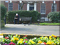
Charles Square, Shoreditch
Not perhaps the prettiest of London's squares, but an oasis of peace close to Old Street nevertheless. It is the responsibility of Hackney Council.
Image: © Stephen McKay
Taken: 7 Mar 2014
0.05 miles
8
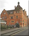
Passmore Edwards Free Library, Shoreditch
Grade II listed library building built in the 1890s to the designs of architect Henry T. Hare. Description at this http://list.english-heritage.org.uk/resultsingle.aspx?uid=1265173. No longer in library use, currently home to the Courtyard Theatre.
Image: © Jim Osley
Taken: 7 Sep 2014
0.05 miles
10

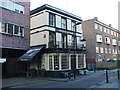
Charles Square, Hoxton
Seen at the junction with Pitfield Street.
Image: © Stephen McKay
Taken: 14 Sep 2009
0.05 miles