IMAGES TAKEN NEAR TO
Shelford Place, LONDON, N16 9HS
Introduction
This page details the photographs taken nearby to Shelford Place, N16 9HS by members of the Geograph project.
The Geograph project started in 2005 with the aim of publishing, organising and preserving representative images for every square kilometre of Great Britain, Ireland and the Isle of Man.

There are currently over 7.5m images from over14,400 individuals and you can help contribute to the project by visiting https://www.geograph.org.uk
Image Map
Images are licensed for reuse under creativecommons.org/licenses/by-sa/2.0
Notes
- Clicking on the map will re-center to the selected point.
- The higher the marker number, the further away the image location is from the centre of the postcode.
Image Listing (282 Images Found)
Images are licensed for reuse under creativecommons.org/licenses/by-sa/2.0
Image
Details
Distance
4
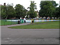
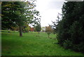
Clissold Park, Paddling Pool, London N16
The paddling pool is most easily accessed from any of the Church Street entrances. It's an ideal spot to cool off, is shallow and just perfect for the under 5's.
Image: © Chris Sitton
Taken: 17 Jun 2007
0.07 miles
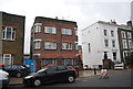
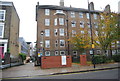
6
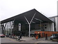
Clissold Leisure Centre, Hackney
Large modern swimming pool and sports facility on Clissold Road.
Image: © David Anstiss
Taken: 3 Feb 2013
0.08 miles
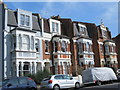
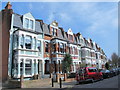
8
Carysfort Road
Connects Clissold Crescent and Albion Road and mostly runs parallel to Clissold Crescent, but joining to it at each end.
Image: © Finlay Cox
Taken: 28 Dec 2011
0.09 miles