IMAGES TAKEN NEAR TO
Templeton Close, LONDON, N16 8UY
Introduction
This page details the photographs taken nearby to Templeton Close, N16 8UY by members of the Geograph project.
The Geograph project started in 2005 with the aim of publishing, organising and preserving representative images for every square kilometre of Great Britain, Ireland and the Isle of Man.

There are currently over 7.5m images from over14,400 individuals and you can help contribute to the project by visiting https://www.geograph.org.uk
Image Map
Images are licensed for reuse under creativecommons.org/licenses/by-sa/2.0
Notes
- Clicking on the map will re-center to the selected point.
- The higher the marker number, the further away the image location is from the centre of the postcode.
Image Listing (242 Images Found)
Images are licensed for reuse under creativecommons.org/licenses/by-sa/2.0
Image
Details
Distance
1
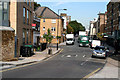
Dalston: Crossway
Looking northeast from Boleyn Road. The traffic lights at the far end mark where Crossway meets the A10, which at this point changes from being Kingsland High Street (to the south) to Stoke Newington Road (to the north).
Image: © Dr Neil Clifton
Taken: 7 Oct 2010
0.04 miles
3
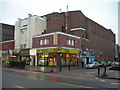
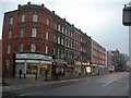
Corner of Stoke Newington Road N16 and Truman Road
This looks like a converted cinema. Now occupied by a Snooker Hall, Hairdressers, Estate Agent and a Cafe. The Tava Restaurant is one of several cafes in the vicinity that serve Turkish food. It caters for a sizeable Turkish community locally, but non Turkish visitors are welcomed. For only a little more money than you would pay for a "meal" at one of the established fast food chains, you get plenty of good, tasty food with friendly service. Highly recommended.
Image: © Danny P Robinson
Taken: 20 Feb 2007
0.05 miles
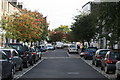
4
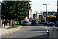
Stoke Newington Road, N16
Near Truman Road, looking North.
Image: © Danny P Robinson
Taken: 20 Feb 2007
0.05 miles

6
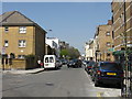
Dalston: John Campbell Road
Looking east from its junction with Crossway, towards Kingsland High Street. This eastern stub is all that now remains of John Campbell Road. Formerly it was a much longer road, with a portion extending west of Boleyn Road (formerly Back Road). It lost this part when the new road, Crossway, was built after WWI.
Image: © Dr Neil Clifton
Taken: 7 Oct 2010
0.05 miles
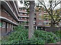
7
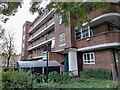
Flats on Stoke Newington Road
These are art deco style
Image: © David Howard
Taken: 7 Nov 2021
0.05 miles
9
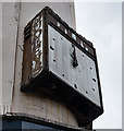
Clock, Dalston
A reminder that on this site was Dudley's department store serving the people of Dalston.
Image: © Jim Osley
Taken: 7 Sep 2017
0.07 miles