IMAGES TAKEN NEAR TO
Leweston Place, LONDON, N16 6RJ
Introduction
This page details the photographs taken nearby to Leweston Place, N16 6RJ by members of the Geograph project.
The Geograph project started in 2005 with the aim of publishing, organising and preserving representative images for every square kilometre of Great Britain, Ireland and the Isle of Man.

There are currently over 7.5m images from over14,400 individuals and you can help contribute to the project by visiting https://www.geograph.org.uk
Image Map
Images are licensed for reuse under creativecommons.org/licenses/by-sa/2.0
Notes
- Clicking on the map will re-center to the selected point.
- The higher the marker number, the further away the image location is from the centre of the postcode.
Image Listing (71 Images Found)
Images are licensed for reuse under creativecommons.org/licenses/by-sa/2.0
Image
Details
Distance
1
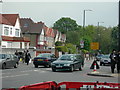
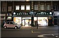
Clapton Common
This part of London (Stamford Hill) is home to many Orthodox Jews. Note the way the men are dressed in this photo -- many men in this area dress like this.
Image: © Danny P Robinson
Taken: 14 May 2006
0.04 miles
2
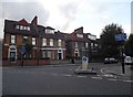
Darenth Road at the junction of Portland Avenue
Image: © David Howard
Taken: 2 Oct 2014
0.07 miles
3
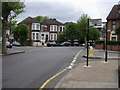
Portland Avenue
Portland Avenue where Darenth Road cuts across
Image: © Shaun Ferguson
Taken: 7 May 2009
0.08 miles

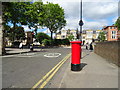
5
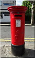
George V postbox on Portland Avenue, Stamford Hill, London N16
Postbox No. N16 11.
See Image] for context.
Image: © JThomas
Taken: 6 Jul 2019
0.10 miles
6
Grodzinski's bakery on Clapton Common
This is one of the oldest and best established groups of Jewish bakeries in North London. Kossoff's was based nearby but declined and is now down to a single branch in Kentish Town owned by the founder's son.
Image: © David Howard
Taken: 28 Aug 2022
0.10 miles
7
Portland Avenue, Stamford Hill, London N16
Showing position of Postbox No. N16 11.
See Image] for postbox.
Image: © JThomas
Taken: 6 Jul 2019
0.11 miles
8
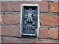
Flush Bracket S7178
Ordnance Survey flush bracket on Skinners' Company's School for Girls, not visible from the road but halfway down some steps leading to the basement. This flush bracket was established during the Third geodetic levelling of England & Wales (1950-68). It was included on the Croydon to Buntingford levelling line and verified by the OS in 1974 with a height of 31.908m above sea level (Newlyn datum).
Image: © Shantavira
Taken: 15 Apr 2009
0.11 miles
9
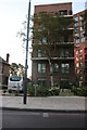
New flats on Clapton Common
They were finished two years ago.
Image: © David Howard
Taken: 25 Jun 2024
0.12 miles
10
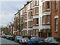
Holmleigh Road, Stamford Hill
The mansion block on the north side of Holmleigh Road is named Carlton Mansions.
Image: © Stephen McKay
Taken: 29 Jan 2010
0.12 miles