IMAGES TAKEN NEAR TO
Chardmore Road, LONDON, N16 6JH
Introduction
This page details the photographs taken nearby to Chardmore Road, N16 6JH by members of the Geograph project.
The Geograph project started in 2005 with the aim of publishing, organising and preserving representative images for every square kilometre of Great Britain, Ireland and the Isle of Man.

There are currently over 7.5m images from over14,400 individuals and you can help contribute to the project by visiting https://www.geograph.org.uk
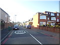
Image Map (86 Images)


Leaflet Map data © OpenStreetMap
Images are licensed for reuse under creativecommons.org/licenses/by-sa/2.0
Notes
- Clicking on the map will re-center to the selected point.
- The higher the marker number, the further away the image location is from the centre of the postcode.
Image Listing (86 Images Found)
Images are licensed for reuse under creativecommons.org/licenses/by-sa/2.0
Image
Details
Distance
6
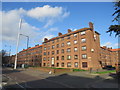
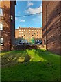
Fawcett Estate, Upper Clapton
Fawcett Estate comprises blocks of flats in Upper Clapton, in inner north east London.
Image: © Malc McDonald
Taken: 1 Feb 2020
0.06 miles
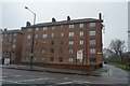
9
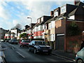
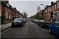
Gilda Crescent, N16
Almost every house on this road has been extended. This is an area where many Orthodox Jewish families live, and many have large households.
Image: © Danny P Robinson
Taken: 3 Dec 2006
0.07 miles