IMAGES TAKEN NEAR TO
Lordship Road, LONDON, N16 5HJ
Introduction
This page details the photographs taken nearby to Lordship Road, N16 5HJ by members of the Geograph project.
The Geograph project started in 2005 with the aim of publishing, organising and preserving representative images for every square kilometre of Great Britain, Ireland and the Isle of Man.

There are currently over 7.5m images from over14,400 individuals and you can help contribute to the project by visiting https://www.geograph.org.uk
Image Map
Images are licensed for reuse under creativecommons.org/licenses/by-sa/2.0
Notes
- Clicking on the map will re-center to the selected point.
- The higher the marker number, the further away the image location is from the centre of the postcode.
Image Listing (131 Images Found)
Images are licensed for reuse under creativecommons.org/licenses/by-sa/2.0
Image
Details
Distance
2
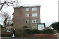
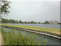
View of houses on Lordship Road from the New River Walkway
Looking north-northeast.
Image: © Robert Lamb
Taken: 15 Jun 2013
0.03 miles
4
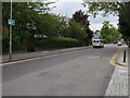
Lordship Road
Lordship Road passing Fairholt Road to go up between the East and West Reservoirs
Image: © Shaun Ferguson
Taken: 7 May 2009
0.03 miles
5
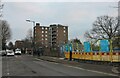
View of the three towerblocks of Lincoln Court, Bethune Road and flats on Lordship Road from the New River Walkway
Looking north-northeast.
Image: © Robert Lamb
Taken: 15 Jun 2013
0.04 miles
7
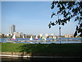
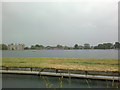
View of the North London Association Yachts on the West Reservoir and three towerblocks on Bethune Road
Looking north-northeast.
Image: © Robert Lamb
Taken: 29 Mar 2014
0.07 miles
8

View of Lincoln Court, Bethune Road and flats on Lordship Road from the New River Walkway
Looking north-northeast.
Image: © Robert Lamb
Taken: 29 Mar 2014
0.07 miles
9
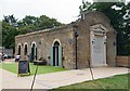
Cafe, Woodberry Wetlands
The cafe occupies a Grade II listed 19th century former gas house, Woodberry Wetlands. Description at this https://historicengland.org.uk/listing/the-list/list-entry/1265631. A brief history of the Gas House may be found at this http://idox.hackney.gov.uk/WAM/doc/Other-416698.pdf?extension=.pdf&id=416698&location=VOLUME1&contentType=&pageCount=1.
Image: © Jim Osley
Taken: 18 Aug 2016
0.08 miles
10
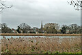
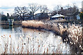
View over East Reservoir towards Stoke Newington church
Image: © Robin Webster
Taken: 5 Feb 2011
0.09 miles