IMAGES TAKEN NEAR TO
Ferndale Road, LONDON, N15 6UG
Introduction
This page details the photographs taken nearby to Ferndale Road, N15 6UG by members of the Geograph project.
The Geograph project started in 2005 with the aim of publishing, organising and preserving representative images for every square kilometre of Great Britain, Ireland and the Isle of Man.

There are currently over 7.5m images from over14,400 individuals and you can help contribute to the project by visiting https://www.geograph.org.uk
Image Map
Images are licensed for reuse under creativecommons.org/licenses/by-sa/2.0
Notes
- Clicking on the map will re-center to the selected point.
- The higher the marker number, the further away the image location is from the centre of the postcode.
Image Listing (78 Images Found)
Images are licensed for reuse under creativecommons.org/licenses/by-sa/2.0
Image
Details
Distance
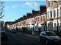
2
Elm Park Avenue looking toward Crowland Primary School
Image: © David Howard
Taken: 5 Feb 2014
0.06 miles
3
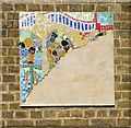
Unfinished mosaic, Crowland Primary School
Image: © Jim Osley
Taken: 18 Jul 2014
0.07 miles
4

Crowland Primary School
Built 1911. http://www.british-history.ac.uk/report.aspx?compid=26998
Image: © Jim Osley
Taken: 18 Jul 2014
0.07 miles
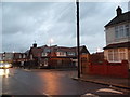
5
Crowland Road at the junction of Elm Park Avenue
The roof extensions opposite were built in the last year or so.
Image: © David Howard
Taken: 5 Feb 2014
0.07 miles
6
Looking east from South Tottenham station
The Tottenham & Hampstead Junction Railway was planned to run from Tottenham Hale on the Great Eastern Railway to Gospel Oak on the Hampstead Junction section of the London & North Western Railway. It was worked by the North London Railway (NLR) from its opening in 1860, and in 1864 came under NLR control. On 21st July 1868 a new line opened from Tottenham Hale to Highgate Road. It was only in 1887 that an extension to Gospel Oak was achieved but as a passenger exchange not as a junction.
On 9th July 1894, the Tottenham & Forest Gate Railway was opened for through goods and passenger trains and had stations at Blackhorse Road, Walthamstow, Leyton, Leytonstone and Wanstead Park. Up to 1912 the line was a joint railway operated by the Midland Railway and the London, Tilbury & Southend Railway but from 1912 it was solely operated by the Midland. With the opening of the new line the Midland extended some of its South Tottenham trains to East Ham.
The line which now ran between Kentish Town and Barking was considered for closure to passengers in 1963 as part of the Beeching Axe, but it remained open. Even so, it was allowed to fall into a poor state of repair and reliability, and by 1980 had been cut back to an hourly service between Kentish Town and Barking. The station canopies were gradually demolished, ticket offices closed and staff withdrawn from stations.
The situation began to improve from 1981 when a new link to Gospel Oak was built and the hourly service from Kentish Town to Barking was replaced by the present route from Gospel Oak to Barking with two trains per hour.
Now with it being taken over by Transport for London as part of the London Overground network the whole line has a new lease of life and new trains run every 15 minutes between Barking and Gospel Oak.
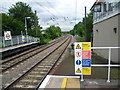
South Tottenham station was opened on 1st May 1871 as 'Tottenham and Stamford Hill' station and became 'South Tottenham' on 1st July 1903. Trains to Barking take the left hand branch ahead while the line straight on joins the Temple Mills branch of the Lea Valley Lines. The signal box is still operational.
Image: © Marathon
Taken: 4 Jun 2014
0.07 miles
7
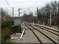
South Tottenham East Junction
The original Tottenham and Hampstead line is the right route on an easy curve. The later Tottenham and Forest Gate line goes left on a sharper curve. As may be seen from the speed limits, the cant at the junction has been optimised for the Forest Gate route. This became the more important route early on, linking the London, Tilbury and Southend Railway with the rest of the network and avoiding the Great Eastern. It was the only independent link the Midland Railway had with their new purchase when they took over the LTSR in 1912. Today it carries the Overground Gospel Oak - Barking service as well as freight.
Image: © Robin Webster
Taken: 5 Feb 2011
0.08 miles
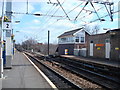
9
South Tottenham station
East bound train from Gospel Oak to Barking. The heavy engineering work for electrification is done but the overhead wires are yet to be put up. This once Cinderella line will soon be an important link in the London rail system.
Image: © John Kingdon
Taken: 7 Mar 2017
0.09 miles
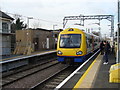
10
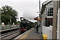
South Tottenham Station (plus Mayflower) 2023
Steam loco 61306 Mayflower surprises commuters as it powers through the station on an excursion from Southend to the south coast journeying through our north London byways
Image: © John Kingdon
Taken: 31 May 2023
0.09 miles