IMAGES TAKEN NEAR TO
Grove Park Road, LONDON, N15 4SN
Introduction
This page details the photographs taken nearby to Grove Park Road, N15 4SN by members of the Geograph project.
The Geograph project started in 2005 with the aim of publishing, organising and preserving representative images for every square kilometre of Great Britain, Ireland and the Isle of Man.

There are currently over 7.5m images from over14,400 individuals and you can help contribute to the project by visiting https://www.geograph.org.uk
Image Map
Images are licensed for reuse under creativecommons.org/licenses/by-sa/2.0
Notes
- Clicking on the map will re-center to the selected point.
- The higher the marker number, the further away the image location is from the centre of the postcode.
Image Listing (112 Images Found)
Images are licensed for reuse under creativecommons.org/licenses/by-sa/2.0
Image
Details
Distance
1
NEW
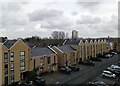
New housing off Lawrence Street, N15
Built on the site of former small industrial units
Image: © Bikeboy
Taken: 22 Feb 2025
0.06 miles
2
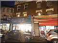
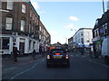
A504 West Green Road
Looking east from a bus.
Image: © Robin Webster
Taken: 5 Feb 2011
0.08 miles
3
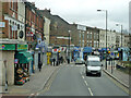
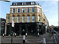
Shops on West Green Road, South Tottenham
Image: © David Howard
Taken: 8 Dec 2016
0.09 miles
6
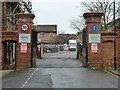
Gates to Portland Place
A gated estate on the site of cold stores, earlier the site was a brewery and ice factory.
Image: © Robin Webster
Taken: 22 Jan 2011
0.12 miles
7
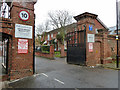
Gates to Portland Place
A gated estate on the site of cold stores, earlier the site was a brewery and ice factory.
Image: © Robin Webster
Taken: 22 Jan 2011
0.12 miles
8
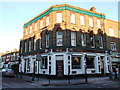
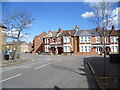
True Craft pub West Green Road London N15
Up until only 7 years ago this pub was called simply the West Green although often it was referred to as the West Green Tavern. It was a pub that served almost exclusively the local African-Caribbean population. Now it has been made over and serves a hipster clientele as gentrification moves on apace in an area that once had affordable housing but now does not. In this process I always wonder where the displaced populations go.
Image: © John Kingdon
Taken: 9 Feb 2023
0.13 miles
9
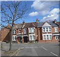
Clyde Circus
Clyde Circus is seen here from Clyde Road. Clyde Circus has a circular group of houses in the middle with small back gardens and what looks like a central communal area.
The central feature is Clyde Circus itself laid out in the late 18th century as the centre piece of a grand approach from Tottenham Green to the east to the former Downhills House to the west. The very interesting Haringey Council web site about the Conservation Area (of which Clyde Circus is the centre piece) has a series of Ordnance Survey Maps which show that although the Circus was here much earlier the houses were not built at the time of the 1894-96 Ordnance Survey Map but appeared on the 1915 Ordnance Survey Map.
Image: © Marathon
Taken: 31 Mar 2015
0.13 miles
10
Clyde Circus
Clyde Circus is seen here from Clyde Road. Clyde Circus has a circular group of houses in the middle with small back gardens and what looks like a central communal area.
The central feature is Clyde Circus itself laid out in the late 18th century as the centre piece of a grand approach from Tottenham Green to the east to the former Downhills House to the west. The very interesting Haringey Council web site about the Conservation Area (of which Clyde Circus is the centre piece) has a series of Ordnance Survey Maps which show that although the Circus was here much earlier the houses were not built at the time of the 1894-96 Ordnance Survey Map but appeared on the 1915 Ordnance Survey Map.
Image: © Marathon
Taken: 31 Mar 2015
0.13 miles