IMAGES TAKEN NEAR TO
Rangemoor Road, LONDON, N15 4LU
Introduction
This page details the photographs taken nearby to Rangemoor Road, N15 4LU by members of the Geograph project.
The Geograph project started in 2005 with the aim of publishing, organising and preserving representative images for every square kilometre of Great Britain, Ireland and the Isle of Man.

There are currently over 7.5m images from over14,400 individuals and you can help contribute to the project by visiting https://www.geograph.org.uk
Image Map
Images are licensed for reuse under creativecommons.org/licenses/by-sa/2.0
Notes
- Clicking on the map will re-center to the selected point.
- The higher the marker number, the further away the image location is from the centre of the postcode.
Image Listing (144 Images Found)
Images are licensed for reuse under creativecommons.org/licenses/by-sa/2.0
Image
Details
Distance
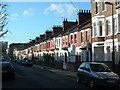
3
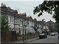
Crowland Road at the junction of Elm Park Avenue
The roof extensions opposite were built in the last year or so.
Image: © David Howard
Taken: 5 Feb 2014
0.09 miles
8
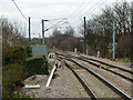
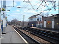
South Tottenham East Junction
The original Tottenham and Hampstead line is the right route on an easy curve. The later Tottenham and Forest Gate line goes left on a sharper curve. As may be seen from the speed limits, the cant at the junction has been optimised for the Forest Gate route. This became the more important route early on, linking the London, Tilbury and Southend Railway with the rest of the network and avoiding the Great Eastern. It was the only independent link the Midland Railway had with their new purchase when they took over the LTSR in 1912. Today it carries the Overground Gospel Oak - Barking service as well as freight.
Image: © Robin Webster
Taken: 5 Feb 2011
0.11 miles
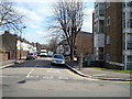
10

Crowland Primary School
Built 1911. http://www.british-history.ac.uk/report.aspx?compid=26998
Image: © Jim Osley
Taken: 18 Jul 2014
0.11 miles