IMAGES TAKEN NEAR TO
Summerhill Road, LONDON, N15 4HD
Introduction
This page details the photographs taken nearby to Summerhill Road, N15 4HD by members of the Geograph project.
The Geograph project started in 2005 with the aim of publishing, organising and preserving representative images for every square kilometre of Great Britain, Ireland and the Isle of Man.

There are currently over 7.5m images from over14,400 individuals and you can help contribute to the project by visiting https://www.geograph.org.uk
Image Map
Images are licensed for reuse under creativecommons.org/licenses/by-sa/2.0
Notes
- Clicking on the map will re-center to the selected point.
- The higher the marker number, the further away the image location is from the centre of the postcode.
Image Listing (90 Images Found)
Images are licensed for reuse under creativecommons.org/licenses/by-sa/2.0
Image
Details
Distance
2
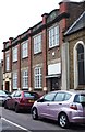
Dorset Hall, West Green Baptist Church
Built 1924 to the designs or architect George W. Newman (attribution foundation stone).
Image: © Jim Osley
Taken: 27 Dec 2014
0.08 miles
3
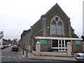
West Green Baptist Church
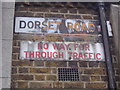
On the junction of Dorset Road (on the left) and West Green Road.
Image: © David Anstiss
Taken: 3 Feb 2013
0.08 miles
4
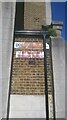
Dorset Road Baptist Church N15
The old alloy road sign is turning orange with age and the warning sign (clearly from a much less hurried age) is rusting gently on the side of the church. A rather romantic piece of slow decay.
Image: © John Kingdon
Taken: 27 May 2022
0.09 miles
5
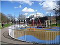
Playground in Elizabeth Place
This small playground brightens up the open space between Elizabeth Place and Clyde Road.
Image: © Marathon
Taken: 31 Mar 2015
0.10 miles
7
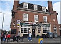
The Palm pub 197 Philip Lane N15
This was the Lord Palmerston pub until about 5 years ago. That was a working class and down at heel pub now revamped and gentrified to serve more hipster patrons. A sign of the encroaching gentrification in N15. At least the building was not demolished for some hideous block of flats and retains the lovely glazed tiling along the bottom of the walls. Also one can see below the near window the tile embossed THB. This stood for Truman Hanbury Buxton, the brewery in East London that built this elegant pub, I think, in the inter war years.
Image: © John Kingdon
Taken: 9 Feb 2023
0.12 miles

10
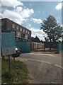
Turner Avenue Estate N15
Taken on a blazing hot day with temperatures up to 31 degrees centigrade. This photo shows block D of the 1950's council estate to the left and, to the right, the works entrance to Brunel Walk where new council homes are being constructed on the site of the now demolished 1970's substandard council homes. My photo {{{7812983}}} shows the other works entrance to the Brunel Walk site.
The neglected state of the pavement and grass show poor maintenance of the existing estate although the buildings are in good condition.
Image: © John Kingdon
Taken: 11 Aug 2024
0.12 miles