IMAGES TAKEN NEAR TO
Colsterworth Road, LONDON, N15 4BG
Introduction
This page details the photographs taken nearby to Colsterworth Road, N15 4BG by members of the Geograph project.
The Geograph project started in 2005 with the aim of publishing, organising and preserving representative images for every square kilometre of Great Britain, Ireland and the Isle of Man.

There are currently over 7.5m images from over14,400 individuals and you can help contribute to the project by visiting https://www.geograph.org.uk
Image Map
Images are licensed for reuse under creativecommons.org/licenses/by-sa/2.0
Notes
- Clicking on the map will re-center to the selected point.
- The higher the marker number, the further away the image location is from the centre of the postcode.
Image Listing (119 Images Found)
Images are licensed for reuse under creativecommons.org/licenses/by-sa/2.0
Image
Details
Distance
1
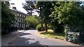
Tottenham Green East
Idyllic scene just a few steps away from the noise and fumes of Tottenham High Road hides the homeless man living in his tent on the Green.
Image: © John Kingdon
Taken: 1 Jul 2019
0.05 miles
2
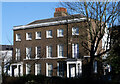
Tottenham Green : pair of houses
These houses are Grade II listed : description at this https://historicengland.org.uk/listing/the-list/list-entry/1189385.
Image: © Jim Osley
Taken: 25 Jan 2021
0.05 miles
3
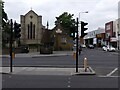
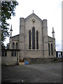
Holy Trinity Church Tottenham
A wealth of historic buildings: Holy Trinity Church and its 1847 Sunday and Infants school, the Tottenham Well and across Philip Lane the Tottenham bus garage.
Image: © John Kingdon
Taken: 31 May 2023
0.05 miles
4
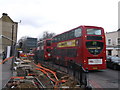
Roadworks on High Road, Tottenham Hale
The pavement along this busy road has been dug up so new electric cables can be installed.
Image: © David Anstiss
Taken: 10 Mar 2013
0.05 miles
6
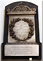
Holy Trinity, Philip Lane, Tottenham Green - Wall monument
Image: © John Salmon
Taken: 24 Jun 2013
0.06 miles
7
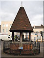
The Old Well, High Road, Tottenham
The Old Well is situated on the junction of Philip Street with High Road Tottenham. It was dug in 1791 and paid for by Thomas Smith, of Bruce Castle who was Lord of the Manor of Tottenham. The tiled roof was added in 1859; it supplied water to the surrounding district but was closed in 1883 when the water became polluted.
Image: © Philip Halling
Taken: 7 Jan 2012
0.06 miles
8
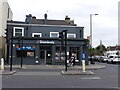
The Swan pub (as was) Tottenham
The Swan pub closed about fourteen years ago and is now a pizza restaurant. The Swan had a reputation for violence which led to its eventual demise. It was however famous as a destination on local buses and stood out painted in, I think, gold and green. Now it is unremarkable in its utilitarianism.
Image: © John Kingdon
Taken: 31 May 2023
0.06 miles
9
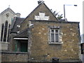
Holy Trinity School and Church, Philip Lane N15
Image: © Robin Sones
Taken: 11 Aug 2011
0.06 miles
10
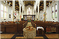
Holy Trinity, Philip Lane, Tottenham Green - East end
Image: © John Salmon
Taken: 24 Jun 2013
0.06 miles