IMAGES TAKEN NEAR TO
Carlingford Road, LONDON, N15 3ED
Introduction
This page details the photographs taken nearby to Carlingford Road, N15 3ED by members of the Geograph project.
The Geograph project started in 2005 with the aim of publishing, organising and preserving representative images for every square kilometre of Great Britain, Ireland and the Isle of Man.

There are currently over 7.5m images from over14,400 individuals and you can help contribute to the project by visiting https://www.geograph.org.uk
Image Map (Loading...)


Getting Data...Please wait
Leaflet Map data © OpenStreetMap
Images are licensed for reuse under creativecommons.org/licenses/by-sa/2.0
Notes
- Clicking on the map will re-center to the selected point.
- The higher the marker number, the further away the image location is from the centre of the postcode.
Image Listing (187 Images Found)
Images are licensed for reuse under creativecommons.org/licenses/by-sa/2.0
Image
Details
Distance
5
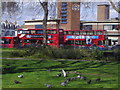
Duckett's Common Harringay
Green Lanes and Turnpike Lane station behind
Image: © David Howard
Taken: 17 Apr 2008
0.05 miles
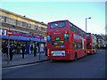
6
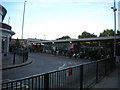
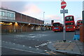
Exit from Turnpike Lane bus station, Hornsey
The vehicular exit onto Green Lanes, with plenty of prospective passengers waiting at stand T.
Image: © Richard Vince
Taken: 23 Sep 2017
0.05 miles
7
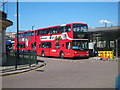
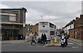
Turnpike Lane bus station
Behind Turnpike Lane Underground station off Green Lanes.
Image: © Oast House Archive
Taken: 26 Jun 2011
0.05 miles
9
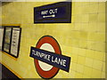
Signage, Turnpike Lane Underground Station
Image: © Robin Sones
Taken: 23 Nov 2010
0.05 miles
10
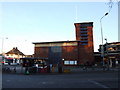
Buses on Green Lanes, Harringay
Outside Turnpike Lane station buildings.
Image: © David Howard
Taken: 25 Nov 2008
0.06 miles