IMAGES TAKEN NEAR TO
Winchmore Hill Road, LONDON, N14 6AD
Introduction
This page details the photographs taken nearby to Winchmore Hill Road, N14 6AD by members of the Geograph project.
The Geograph project started in 2005 with the aim of publishing, organising and preserving representative images for every square kilometre of Great Britain, Ireland and the Isle of Man.

There are currently over 7.5m images from over14,400 individuals and you can help contribute to the project by visiting https://www.geograph.org.uk
Image Map
Images are licensed for reuse under creativecommons.org/licenses/by-sa/2.0
Notes
- Clicking on the map will re-center to the selected point.
- The higher the marker number, the further away the image location is from the centre of the postcode.
Image Listing (277 Images Found)
Images are licensed for reuse under creativecommons.org/licenses/by-sa/2.0
Image
Details
Distance
2
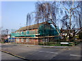
The Wells, London N14
This is a turning off Winchmore Hill Road adjacent to Southgate Swimming Pool. Just beyond the apartment block are some cottages.
Image: © Christine Matthews
Taken: 2 Mar 2011
0.03 miles
3
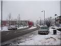
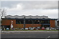
Winchmore Hill Road, Southgate, London N14
Looking down Winchmore Hill Road. The building on the left is a Marks and Spencer Food Store.
Image: © Christine Matthews
Taken: 6 Jan 2010
0.04 miles
4
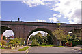
Viaduct carrying Piccadilly Line at end of Mayfair Terrace, London N14
I think that originally the road went through archway and continued, but it has been grassed over and planted with just a footpath through. This side of the archway is Mayfair Terrace, and the other side is Redwood Close. I have called this a viaduct as it seems to me to be more than a bridge.
Image: © Christine Matthews
Taken: 8 Apr 2008
0.04 miles
5
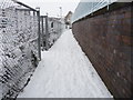
Footpath, Southgate, London N14
Footpath which runs between the Marks and Spencer car park and the boundary wall to the Piccadilly Line, leading from the footbridge over the Piccadilly Line to Winchmore Hill Road.
Image: © Christine Matthews
Taken: 6 Jan 2010
0.04 miles
6
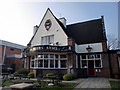
Fishmonger's Arms Public House, Winchmore Hill Road, Southgate, N14
After a brief spell a few years ago of being named "The Southgate", this public house has gone back to its original name of "The Fishmonger's Arms".
Image: © Christine Matthews
Taken: 2 Mar 2011
0.04 miles
7
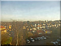
View from train near Southgate, London N14
Shortly before the train enters the tunnel at Southgate the line is raised up on a viaduct and this is the view to the north-east of the train.
Image: © Christine Matthews
Taken: 19 Dec 2008
0.05 miles
8
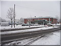
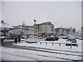
Marks and Spencer Food Store, Winchmore Hill Road, London N14
Looking across Winchmore Hill Road towards the Marks and Spencer Food Store. The car park, which is usually quite full, is noticeably empty owing to the heavy show.
Image: © Christine Matthews
Taken: 6 Jan 2010
0.05 miles
9
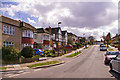
St Thomas Road, London N14
Looking up St Thomas Road towards Winchmore Hill Road from the junction with Redwood Close.
Image: © Christine Matthews
Taken: 8 Apr 2008
0.05 miles
10
Marks and Spencer Food Store Car Park, London N14
Looking across the car park of the Marks and Spencer Food Store in Winchmore Hill road towards the new apartment block.
Image: © Christine Matthews
Taken: 6 Jan 2010
0.05 miles