IMAGES TAKEN NEAR TO
Russell Road, LONDON, N13 4RW
Introduction
This page details the photographs taken nearby to Russell Road, N13 4RW by members of the Geograph project.
The Geograph project started in 2005 with the aim of publishing, organising and preserving representative images for every square kilometre of Great Britain, Ireland and the Isle of Man.

There are currently over 7.5m images from over14,400 individuals and you can help contribute to the project by visiting https://www.geograph.org.uk
Image Map
Images are licensed for reuse under creativecommons.org/licenses/by-sa/2.0
Notes
- Clicking on the map will re-center to the selected point.
- The higher the marker number, the further away the image location is from the centre of the postcode.
Image Listing (133 Images Found)
Images are licensed for reuse under creativecommons.org/licenses/by-sa/2.0
Image
Details
Distance
1
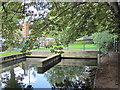
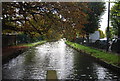
The New River south of Bowes Road (A406, the North Circular Road)
Image: © Mike Quinn
Taken: 9 Sep 2015
0.01 miles
2
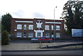
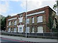
Factory, North Circular Rd
Dated to 1896.
Image: © N Chadwick
Taken: 20 Oct 2013
0.01 miles
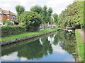
4
The New River south of Bowes Road (A406, the North Circular Road) (3)
See Image The aqueduct emerges here from a U-bend conduit under the North Circular Road.
Image: © Mike Quinn
Taken: 9 Sep 2015
0.02 miles
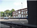
6
The former Roche Laboratories by the North Circular Road (A406)
Image: © Mike Quinn
Taken: 9 Sep 2015
0.02 miles
7
The North Circular Road, Bounds Green
Taken from under the railway bridge
Image: © David Howard
Taken: 26 May 2018
0.02 miles
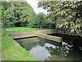
8
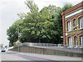
The North Circular Road (A406) (2)
Before 1962/63, when the North Circular Road was enlarged, there was a hump-backed bridge over the New River at this point. It was not possible to raise sufficiently the level of the new road under the nearby railway bridge just to the west Image So the aqueduct was put into a U-bend conduit under the road. However, the pavement on the south side of the road still rises in an arc some 8 ft above the level of the carriageway (to the height of the original bridge).
See also Image for info about the New River.
Image: © Mike Quinn
Taken: 9 Sep 2015
0.02 miles
10
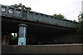
Railway bridge on the North Circular Road, Bowes Park
Image: © David Howard
Taken: 19 May 2019
0.03 miles