IMAGES TAKEN NEAR TO
Broomfield Avenue, LONDON, N13 4JQ
Introduction
This page details the photographs taken nearby to Broomfield Avenue, N13 4JQ by members of the Geograph project.
The Geograph project started in 2005 with the aim of publishing, organising and preserving representative images for every square kilometre of Great Britain, Ireland and the Isle of Man.

There are currently over 7.5m images from over14,400 individuals and you can help contribute to the project by visiting https://www.geograph.org.uk
Image Map
Images are licensed for reuse under creativecommons.org/licenses/by-sa/2.0
Notes
- Clicking on the map will re-center to the selected point.
- The higher the marker number, the further away the image location is from the centre of the postcode.
Image Listing (219 Images Found)
Images are licensed for reuse under creativecommons.org/licenses/by-sa/2.0
Image
Details
Distance
1

Broomfield Avenue, London N13
This road used to be a junction with Aldermans Hill, but it was blocked off some time with, not only the pavement but bollards as well.
Image: © Christine Matthews
Taken: 26 Mar 2013
0.03 miles
2

Broomfield Avenue, London N13
This road used to be a junction with Aldermans Hill, but it was blocked off some time with, not only the pavement but bollards as well.
Image: © Christine Matthews
Taken: 26 Mar 2013
0.03 miles

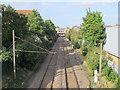
4
Hertford Loop Line
The railway line seen on the approach to Palmers Green station. The building on the left is Morrison's supermarket. The bridge in the distance carries Broomfield Lane over the line. Alexandra Palace is just visible through the murk on the horizon.
Image: © Martin Addison
Taken: 20 Jan 2012
0.05 miles
5
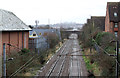
Towards London on Hertford Loop from Palmers Green
View south from Aldermans Hill bridge, towards Alexandra Palace (Wood Green until 5/82), Finsbury Park and London (see also Image]). The bridge ahead is Broomfield Lane and the Television Transmission Tower at Alexandra Palace can be seen on the horizon.
Image: © Ben Brooksbank
Taken: 8 Aug 2009
0.05 miles
6
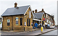
Palmers Green Station
Built by the Great Northern Railway in 1870, the ticket office closely matches the one at Totteridge and Whetstone on the Barnet Branch of the Northern Line - also a GNR constructed railway line.
Image: © Martin Addison
Taken: 20 Jan 2012
0.06 miles
8
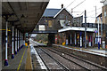
Palmers Green Station
Looking along the tracks towards the ticket office. The steel beam carrying the weight of the building bears the date 1870. It is interesting to note that the awning on the down platform is much shorter than the one provided for London bound passengers. Perhaps the Great Northern Railway, often strapped for cash, decided to make a saving there?
Image: © Martin Addison
Taken: 20 Jan 2012
0.06 miles
9
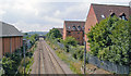
Railway lines south of Palmers Green station
Image: © Mike Quinn
Taken: 9 Sep 2015
0.06 miles
10
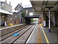
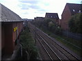
Palmers Green station
The Alexandra Palace-Hertford-Stevenage loop was built mainly as a by-pass for the approaches to King's Cross on the main line from Hatfield and was built to main line standards for much of its length. However, it has never carried regular long-distance passenger services and has always primarily been a suburban branch, apart from when there is engineering work or other disruption on the East Coast Main Line through Hatfield.
The line was opened as far as Enfield, which was then the terminus, on 1st April 1871. The line was extended to Cuffley from 4th April 1910 and on to Stevenage for freight on 4th March 1918, but passenger trains only started beyond Cuffley on 2nd June 1924.
Palmers Green station was opened with that section of the line on 1st April 1871. At that time it was described as "a little gathering of houses on the road to Enfield" but the station was placed on the road to Southgate, a village just under a mile away to the north-west which was much favoured by wealthy businessmen for whose benefit a privately-operated horse-bus feeder service was started. Villa development at Palmers Green did not really take off until about 1900 when side streets sprouted out each side of the Enfield Road from Wood Green to Winchmore Hill. In 1905 the Evening News saw "Palmers Green and Southgate, 30 minutes journey from the City, as the places where the bank clerk or the man with a responsible position in a merchant's office could find the home he desired."
This view from the down platform looks towards the bridge carrying Aldermans Hill over the line. The next station in this direction is Bowes Park.
Image: © Marathon
Taken: 21 Oct 2015
0.06 miles