IMAGES TAKEN NEAR TO
Broomfield Avenue, LONDON, N13 4JJ
Introduction
This page details the photographs taken nearby to Broomfield Avenue, N13 4JJ by members of the Geograph project.
The Geograph project started in 2005 with the aim of publishing, organising and preserving representative images for every square kilometre of Great Britain, Ireland and the Isle of Man.

There are currently over 7.5m images from over14,400 individuals and you can help contribute to the project by visiting https://www.geograph.org.uk
Image Map
Images are licensed for reuse under creativecommons.org/licenses/by-sa/2.0
Notes
- Clicking on the map will re-center to the selected point.
- The higher the marker number, the further away the image location is from the centre of the postcode.
Image Listing (268 Images Found)
Images are licensed for reuse under creativecommons.org/licenses/by-sa/2.0
Image
Details
Distance
1
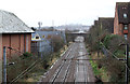
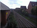
Hertford Loop Line
The railway line seen on the approach to Palmers Green station. The building on the left is Morrison's supermarket. The bridge in the distance carries Broomfield Lane over the line. Alexandra Palace is just visible through the murk on the horizon.
Image: © Martin Addison
Taken: 20 Jan 2012
0.06 miles
2
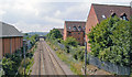
Towards London on Hertford Loop from Palmers Green
View south from Aldermans Hill bridge, towards Alexandra Palace (Wood Green until 5/82), Finsbury Park and London (see also Image]). The bridge ahead is Broomfield Lane and the Television Transmission Tower at Alexandra Palace can be seen on the horizon.
Image: © Ben Brooksbank
Taken: 8 Aug 2009
0.06 miles
3
Broomfield Avenue, N13 (5)
The east side, north of Broomfield Lane.
Image: © Mike Quinn
Taken: 9 Sep 2015
0.07 miles
4

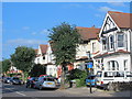
Broomfield Avenue, London N13
This road used to be a junction with Aldermans Hill, but it was blocked off some time with, not only the pavement but bollards as well.
Image: © Christine Matthews
Taken: 26 Mar 2013
0.07 miles
5

Broomfield Avenue, London N13
This road used to be a junction with Aldermans Hill, but it was blocked off some time with, not only the pavement but bollards as well.
Image: © Christine Matthews
Taken: 26 Mar 2013
0.07 miles

7
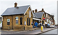
Palmers Green Station
Built by the Great Northern Railway in 1870, the ticket office closely matches the one at Totteridge and Whetstone on the Barnet Branch of the Northern Line - also a GNR constructed railway line.
Image: © Martin Addison
Taken: 20 Jan 2012
0.09 miles
8
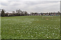
Football Pitch, Broomfield Park, London N13
Football Pitch as seen from the main path in Broomfield Park close to the Aldermans Hill Palmers Green entrance.
Image: © Christine Matthews
Taken: 26 Mar 2013
0.09 miles
10
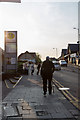
Aldermans Hill, London N13
Looking up the hill towards the station, with Morrisons on the left.
Image: © Christine Matthews
Taken: 7 May 2013
0.09 miles