IMAGES TAKEN NEAR TO
Lynton Avenue, LONDON, N12 9JH
Introduction
This page details the photographs taken nearby to Lynton Avenue, N12 9JH by members of the Geograph project.
The Geograph project started in 2005 with the aim of publishing, organising and preserving representative images for every square kilometre of Great Britain, Ireland and the Isle of Man.

There are currently over 7.5m images from over14,400 individuals and you can help contribute to the project by visiting https://www.geograph.org.uk
Image Map
Images are licensed for reuse under creativecommons.org/licenses/by-sa/2.0
Notes
- Clicking on the map will re-center to the selected point.
- The higher the marker number, the further away the image location is from the centre of the postcode.
Image Listing (24 Images Found)
Images are licensed for reuse under creativecommons.org/licenses/by-sa/2.0
Image
Details
Distance
1
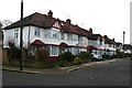
Lynton Avenue North Finchley
The junction of Lynton Ave. with Finchley Park close to North Middlesex golf course.
Image: © Nigel Mykura
Taken: 22 Dec 2008
0.02 miles
2
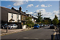
Finchley Park
A side street off the High Road, North Finchley. It is a cul-de-sac with a connecting side street to Mayfield Avenue close to the distant end.
Image: © Martin Addison
Taken: 5 Sep 2009
0.13 miles
4
Mayfield Avenue
A quiet suburban street off the High Road, North Finchley, leading to Friary Road.
Image: © Martin Addison
Taken: 5 Sep 2009
0.15 miles
5
North Finchley, stenchpipe
One of several in the area; this is on Friern Watch Avenue, and is badged for Finchley District Council, and made by J Gibb & Co Ltd, London.
Image: © Mike Faherty
Taken: 4 Aug 2012
0.17 miles
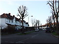
6
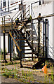
Fire Escape
At the rear of the closed Furniture-Land store on the High Road, North Finchley. The view is taken from Mayfield Avenue.
Image: © Martin Addison
Taken: 5 Sep 2009
0.17 miles
7
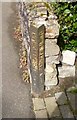
Old Boundary Marker by Ravensdale Avenue, Finchley parish
Parish Boundary Marker by the UC road, in parish of Finchley (Barnet District), Ravensdale Avenue N12, left side of drive to No 49.
Inscription reads vertically:-
: BOROUGH OF FINCHLEY : : FRIERN BARNET U.D. :
Surveyed
Milestone Society National ID: MX_FICFBA01pb
Image: © Milestone Society
Taken: Unknown
0.18 miles
8
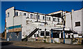
Closed Furniture-Land
Located on the High Road (A1000), the Furniture-Land store closed a few years back. The premises remain in the hands of the receivers, but may open as shops or a convenience store in the future. In the meantime, a few tenants remain in the flats above.
Image: © Martin Addison
Taken: 5 Sep 2009
0.18 miles
9
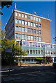
Britannia House
Office premises located on the High Road, North Finchley, at the junction with Britannia Road - the sign for which is leaning like an attendee at the last night of the proms!
Image: © Martin Addison
Taken: 5 Sep 2009
0.18 miles
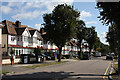
10
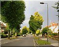
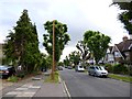
Ravensdale Avenue, North Finchley
Typical 1930's suburban residential development - of a kind that could be matched in many outer London boroughs. The curious lollipop-shaped trees caught my eye - limes, I think.
Image: © Stefan Czapski
Taken: 6 Jul 2014
0.19 miles