IMAGES TAKEN NEAR TO
Park View Court, Torrington Park, LONDON, N12 9AJ
Introduction
This page details the photographs taken nearby to Park View Court, Torrington Park, N12 9AJ by members of the Geograph project.
The Geograph project started in 2005 with the aim of publishing, organising and preserving representative images for every square kilometre of Great Britain, Ireland and the Isle of Man.

There are currently over 7.5m images from over14,400 individuals and you can help contribute to the project by visiting https://www.geograph.org.uk
Image Map
Images are licensed for reuse under creativecommons.org/licenses/by-sa/2.0
Notes
- Clicking on the map will re-center to the selected point.
- The higher the marker number, the further away the image location is from the centre of the postcode.
Image Listing (61 Images Found)
Images are licensed for reuse under creativecommons.org/licenses/by-sa/2.0
Image
Details
Distance
1
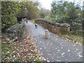
Bridge in Priory Park
The dog was waiting for me to come and make a fuss of it.
Image: © David Howard
Taken: 6 Nov 2014
0.03 miles
2
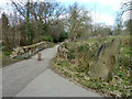
Bridge over Blacketts Brook, Friary Park
The brook flows via Pymmes Brook into the Lea.
Image: © Robin Webster
Taken: 6 Apr 2013
0.03 miles
3
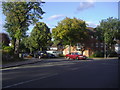
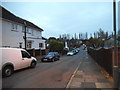
Torrington Park at junction of Friary Way
Image: © David Howard
Taken: 4 Sep 2009
0.03 miles
6
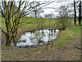
Small pond, Friary Park
This is probably seasonal.
Image: © Robin Webster
Taken: 6 Apr 2013
0.05 miles
7
Friary Way at the junction of Valley Avenue
Image: © David Howard
Taken: 6 Nov 2014
0.05 miles
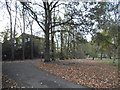
8
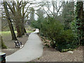
Path in Friary Park
Once a private park, it was opened to the public in 1910.
Image: © Robin Webster
Taken: 6 Apr 2013
0.06 miles
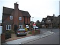
9

Ashurst Close, Friern Barnet
View along Ashurst Close from near the junction with Torrington Park
Image: © Nigel Mykura
Taken: 22 Dec 2008
0.06 miles
10
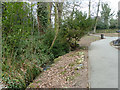
Path by Blacketts Brook, Friary Park
The path leads to an exit onto Friary Road, under which the brook passes via a culvert.
Image: © Robin Webster
Taken: 6 Apr 2013
0.08 miles