IMAGES TAKEN NEAR TO
Avondale Avenue, LONDON, N12 8EL
Introduction
This page details the photographs taken nearby to Avondale Avenue, N12 8EL by members of the Geograph project.
The Geograph project started in 2005 with the aim of publishing, organising and preserving representative images for every square kilometre of Great Britain, Ireland and the Isle of Man.

There are currently over 7.5m images from over14,400 individuals and you can help contribute to the project by visiting https://www.geograph.org.uk
Image Map
Images are licensed for reuse under creativecommons.org/licenses/by-sa/2.0
Notes
- Clicking on the map will re-center to the selected point.
- The higher the marker number, the further away the image location is from the centre of the postcode.
Image Listing (86 Images Found)
Images are licensed for reuse under creativecommons.org/licenses/by-sa/2.0
Image
Details
Distance
1
Train passing over Holden Road, North Finchley
Image: © David Howard
Taken: 3 Feb 2016
0.06 miles
2
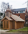
Church of St Cyril of Turau and All the Patron Saints of the Belarusian People, Woodside Park
The first church of wooden construction to be built in London since the Great Fire. A Catholic church built as a memorial to the Cherbonyl nuclear disaster. A full description of the church may be found at this https://www.dezeen.com/2016/12/17/wooden-belarusian-memorial-chapel-dedicated-chernobyl-nuclear-disaster-spheron-architects-london-england/.
Image: © Jim Osley
Taken: 21 Feb 2018
0.08 miles
3
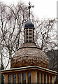
Shingled dome, Woodside Park
On the Church of St Cyril of Turau and All the Patron Saints of the Belarusian People, Woodside Park. More on the church at Image
Image: © Jim Osley
Taken: 21 Feb 2018
0.08 miles
5

St Barnabas Church Finchley
This redbrick church of the Church of England is located in Holden Rd Finchley
Image: © Nigel Mykura
Taken: 22 Dec 2008
0.11 miles
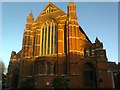
6
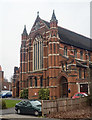
West front, Church of St Barnabas, Woodside Park
Built between 1912 and 1914 to a design by prolific church architect J.S. Alder.
Image: © Jim Osley
Taken: 21 Feb 2018
0.11 miles
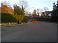
7
Small crane by Woodside Park Station
It's doing piling.
Image: © David Howard
Taken: 24 Apr 2022
0.13 miles
8
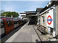
Underground station
Woodside Park underground station.
Image: © Peter Mackenzie
Taken: 12 Sep 2017
0.13 miles
9
Woodside Park Underground station
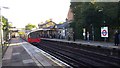
The early railways tended to avoid the high ground in the centre of the present Borough of Barnet. Finchley thus remained a largely agricultural community, providing hay for London's army of horses.
To improve communications, the Edgware, Highgate & London Railway Company opened a line in 1867 from Finsbury Park through East Finchley, and Finchley Central, and to the east of Mill Hill. On 1st April 1872 the company opened a four mile double track northwards through stations, including Torrington Park (later Woodside Park), up the eastern side of the Dollis Brook to High Barnet. The line failed to climb the steep slope up to Chipping (High) Barnet and terminated at the foot of Barnet Hill. A new villa colony near Torrington Park, Woodside caused the station to be renamed ‘Woodside Park for North Finchley’ on 1st May 1882. From 1931 the Woodside Park Garden Suburb was laid out west of the Dollis Brook and its name was added to the boards at Woodside Park station.
The new London Passenger Transport Board came into existence in 1933, and in 1935 a major railway development plan was drawn up. Under the plan, the Tube was to be extended from its then terminus at Archway to the surface at East Finchley. The lines north of East Finchley running out to High Barnet and Edgware would then be connected to the Underground at Archway, replacing the old steam routes. The Northern line was so named in 1937. Tube trains reached East Finchley in 1939 and High Barnet in 1940. Northern line Tube trains to High Barnet started on 14th April 1940 and at this time the name ‘Woodside Park and North Finchley for the Woodside Garden Suburb’ was replaced by Woodside Park. The Underground extension to Edgware from Finchley Central never got further than Mill Hill East and the rest of the project was cancelled after the War when Green Belt legislation came in.
Referring to the stations on the High Barnet branch Alan A Jackson in London’s Local Railways says: “The perceptive travellers can still discern the origins of the line; for the seeing eye ... the atmosphere of a country branch has not entirely gone.”
This view from the up platform of Woodside Park station shows a Morden via Bank train about to leave. The next station in this direction is West Finchley.
Image: © Marathon
Taken: 4 May 2016
0.13 miles
10
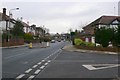
Argyle Rd Finchley
View east up Argyle Rd towards the railway bridge from the junction with Westbury rd.
Image: © Nigel Mykura
Taken: 22 Dec 2008
0.13 miles