IMAGES TAKEN NEAR TO
Argyle Road, LONDON, N12 7HS
Introduction
This page details the photographs taken nearby to Argyle Road, N12 7HS by members of the Geograph project.
The Geograph project started in 2005 with the aim of publishing, organising and preserving representative images for every square kilometre of Great Britain, Ireland and the Isle of Man.

There are currently over 7.5m images from over14,400 individuals and you can help contribute to the project by visiting https://www.geograph.org.uk
Image Map
Images are licensed for reuse under creativecommons.org/licenses/by-sa/2.0
Notes
- Clicking on the map will re-center to the selected point.
- The higher the marker number, the further away the image location is from the centre of the postcode.
Image Listing (45 Images Found)
Images are licensed for reuse under creativecommons.org/licenses/by-sa/2.0
Image
Details
Distance
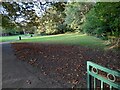
1
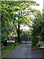
Vehicular Access
Gates to allow entry by council garden maintenance vehicles into the parkland beside Dollis Brook. The sign reminds the workers that, beyond the gates, Argyle Road is very busy.
Image: © Martin Addison
Taken: 29 May 2007
0.02 miles
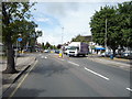
3
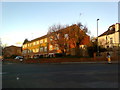
Argyle Road at the junction of Westbury Road
Image: © David Howard
Taken: 3 Feb 2016
0.03 miles
5
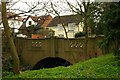
Road bridge over Dollis Brook, Woodside Park
With just a hint of Art Deco.
Image: © Jim Osley
Taken: 12 Mar 2011
0.06 miles
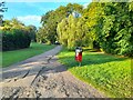
7
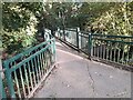
Bridge across Dollis Brook, Woodside Park
The Dollis Brook rises from the Dollis Valley in High Barnet and flows into the River Brent in Finchley.
Image: © David Howard
Taken: 22 Sep 2021
0.06 miles
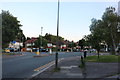
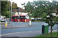
10

Sussex Ring
A roundabout with shops at the junction of, Southover Way, Argyle Road, Walmington Fold and Lullington Garth, which is the road the car is turning onto. The ring has shops only on its west side.
Image: © Martin Addison
Taken: 29 May 2007
0.07 miles