IMAGES TAKEN NEAR TO
Northiam, LONDON, N12 7ET
Introduction
This page details the photographs taken nearby to Northiam, N12 7ET by members of the Geograph project.
The Geograph project started in 2005 with the aim of publishing, organising and preserving representative images for every square kilometre of Great Britain, Ireland and the Isle of Man.

There are currently over 7.5m images from over14,400 individuals and you can help contribute to the project by visiting https://www.geograph.org.uk
Image Map
Images are licensed for reuse under creativecommons.org/licenses/by-sa/2.0
Notes
- Clicking on the map will re-center to the selected point.
- The higher the marker number, the further away the image location is from the centre of the postcode.
Image Listing (34 Images Found)
Images are licensed for reuse under creativecommons.org/licenses/by-sa/2.0
Image
Details
Distance
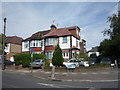
3
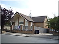
Union Church, Totteridge
A view from the Dollis Valley Greenwalk of the back of the church, which was built in 2001.
The front is shown here Image
Image: © Des Blenkinsopp
Taken: 26 Feb 2019
0.08 miles
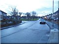
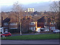
5
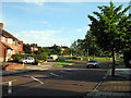
Square-about
View along Southover Way looking towards the square at the junction with Northiam.
Image: © Martin Addison
Taken: 29 May 2007
0.10 miles
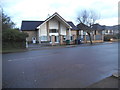
6
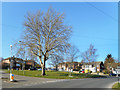
Northiam and Southover
The junction of two roads with single-word names.
Image: © Des Blenkinsopp
Taken: 26 Feb 2019
0.10 miles
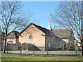
7
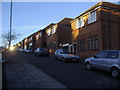
Housing along Southover, Woodside Park
These are maisonettes but some are being used as offices.
Image: © David Howard
Taken: 16 Jan 2008
0.11 miles
9
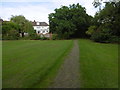
The Dollis Valley Greenwalk near Laurel View
The Dollis Valley Greenwalk is about ten miles long and runs from Hampstead Heath to join the Dollis Brook near the North Circular Road and then follows the brook to beyond its source at Moat Mount.
The Dollis Brook rises at Moat Mount near Arkley, firstly flowing eastwards through the open countryside of Totteridge Fields to Chipping Barnet and then through the suburbs of Barnet to Hendon. Its route can be traced by the thin strip of woodland along the riverbank and ribbon of open land on either side which provides a valuable green corridor. At Hendon the Dollis Brook meets the Mutton Brook and becomes the River Brent which then flows into the Welsh Harp Reservoir and subsequently the River Thames at Brentford.
The house ahead is in Laurel View. Here the Dollis Brook is to the right. Beyond Laurel View is Whetstone Stray Open Space.
Image: © Marathon
Taken: 28 Sep 2016
0.12 miles