1
Colney Hatch Lane
From the Junction with Friern Barnet Road, looking towards Alexandra Palace, which is visible on the horizon. The art deco style building with a flag pole, at the end of the parade of shops, was the youth employment and careers advice centre - the words just legible in the weathering of the white paint.
Image: © Martin Addison
Taken: 11 Aug 2006
0.04 miles
2
Friern Barnet Post Office
Image: © JThomas
Taken: 23 Apr 2016
0.05 miles
3
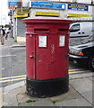
Double Elizabeth II postbox outside Friern Barnet Post Office
Postbox No. N12 24 and postbox No. N12 241.
See
Image] for context.
Image: © JThomas
Taken: 23 Apr 2016
0.05 miles
4
Friern Barnet Post Office
On Woodhouse Road, at the corner of Horsham Avenue.
Image: © Mike Faherty
Taken: 4 Aug 2012
0.05 miles
5
Woodhouse Road, Friern Barnet
VLW77, a Volvo with Wright body, collects passengers for Turnpike Lane Station on the 221 bus route. The shops are set back from Woodhouse Road itself on a service road called Grand Parade. It doesn't look particularly grand on a gloomy Friday though.
Image: © Martin Addison
Taken: 17 Apr 2009
0.06 miles
6
Woodleigh Avenue
Seen from Woodhouse Road. Nice example of late 1920's housing. The road, along with Hollickwood Avenue at the far end, follows the route of a field boundary. There appears to have once been a stream at the bottom of the dip which fed into a fish pond, roughly located at the current junction of Thurlstone Avenue and Lyndhurst Avenue.
Image: © Martin Addison
Taken: 12 Feb 2011
0.07 miles
7
Italian Restaurant, Colney Hatch Lane
Image: © David Howard
Taken: 5 Mar 2008
0.07 miles
8
Italian restaurant on Friern Barnet Road
Image: © JThomas
Taken: 23 Apr 2016
0.08 miles
9
Junction of Friern Barnet Lane and Colney Hatch Lane, London N11
Taken from outside Aldermen Court, looking across the road junction with Colney Hatch Lane.
Image: © Christine Matthews
Taken: 25 Jul 2008
0.08 miles
10
Friern Barnet: front view of the old Town Hall
An alternative view of
Image
Image: © Chris Downer
Taken: 7 Sep 2012
0.09 miles


