IMAGES TAKEN NEAR TO
Heatherdene Close, LONDON, N12 0JQ
Introduction
This page details the photographs taken nearby to Heatherdene Close, N12 0JQ by members of the Geograph project.
The Geograph project started in 2005 with the aim of publishing, organising and preserving representative images for every square kilometre of Great Britain, Ireland and the Isle of Man.

There are currently over 7.5m images from over14,400 individuals and you can help contribute to the project by visiting https://www.geograph.org.uk
Image Map
Images are licensed for reuse under creativecommons.org/licenses/by-sa/2.0
Notes
- Clicking on the map will re-center to the selected point.
- The higher the marker number, the further away the image location is from the centre of the postcode.
Image Listing (91 Images Found)
Images are licensed for reuse under creativecommons.org/licenses/by-sa/2.0
Image
Details
Distance
1
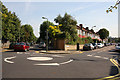
Junction of Bow Lane and Clifton Road
Bow Lane bends to the left and Clifton Road continues straight on. Due to the proximity of parked cars, it is normal to drive straight across the roundabout, with due care of course!
Image: © Martin Addison
Taken: 20 Sep 2008
0.03 miles
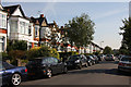
2
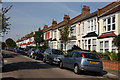
Clifton Road
Terraced housing in two different styles.
Image: © Martin Addison
Taken: 20 Sep 2008
0.05 miles
3
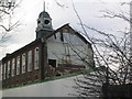
Finchley County School being demolished
I was a pupil at this school from 1949 - 1954 and watched its demolition in 2003
Image: © Ken Amphlett
Taken: 22 Dec 2003
0.07 miles
4
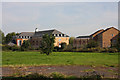
Bow Lane Playing Fields
Looking across the fields towards the apartment development on the Great North Road - the buildings were once a secondary school. The houses on the right are on Heatherdene Close. See Image for more information about Bow Lane Playing Fields.
Image: © Martin Addison
Taken: 20 Sep 2008
0.07 miles
5
Queens Avenue
Looking down the hill to Squires Lane. The houses here are in four residence terraces.
Image: © Martin Addison
Taken: 20 Sep 2008
0.08 miles
6
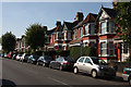
Squires Lane
Brick built terraced housing with alternating roof designs.
Image: © Martin Addison
Taken: 20 Sep 2008
0.08 miles
7

Big Yellow storage, Finchley High Road
The reason for the recent increase in storage warehouses is the shrinking size of new houses which don't have enough room for people's furniture and belongings. Also the price of property has gone up so much people can't afford such large places generally and are having to limit their available space or move too far away instead.
Image: © David Howard
Taken: 18 Nov 2015
0.09 miles
8
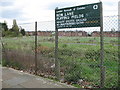
Bow Lane Playing Fields
Not a lot of playing gets done here - the gates are firmly locked with high security padlocks. The tarmac tennis courts are being taken over by trees and brambles. The grass is left to grow. A little piece of Camden in the London Borough of Barnet. Currently (2008) this site is linked with a complete redevelopment of Finchley Memorial Hospital. The flats in the distance are located on the west side of the High Road, (A1000).
Image: © Martin Addison
Taken: 2 May 2006
0.09 miles
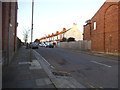
10

Night Emergency
An ambulance and a paramedic attending a night time emergency at an apartment block on High Road, Finchley. The bus stop makes a convenient location to pull off the road. Both crews are inside with the patient.
Image: © Martin Addison
Taken: 28 Jul 2010
0.10 miles