IMAGES TAKEN NEAR TO
Brompton Mews, LONDON, N12 0BF
Introduction
This page details the photographs taken nearby to Brompton Mews, N12 0BF by members of the Geograph project.
The Geograph project started in 2005 with the aim of publishing, organising and preserving representative images for every square kilometre of Great Britain, Ireland and the Isle of Man.

There are currently over 7.5m images from over14,400 individuals and you can help contribute to the project by visiting https://www.geograph.org.uk
Image Map
Images are licensed for reuse under creativecommons.org/licenses/by-sa/2.0
Notes
- Clicking on the map will re-center to the selected point.
- The higher the marker number, the further away the image location is from the centre of the postcode.
Image Listing (109 Images Found)
Images are licensed for reuse under creativecommons.org/licenses/by-sa/2.0
Image
Details
Distance
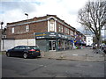
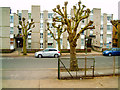
1
Woodlands
The Woodlands Estate is located on the west side of the A1000, High Road, as it approaches North Finchley.
Image: © Martin Addison
Taken: 9 Dec 2006
0.04 miles
8
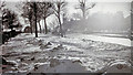
High Road, North Finchley in 1963 Great Freeze
View southward at Kenver Avenue, near Tally-Ho Corner. That winter the snow in London lasted for two months.
Image: © Ben Brooksbank
Taken: 14 Feb 1963
0.09 miles
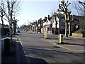
9
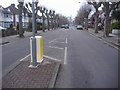
Christchurch Avenue
Looking towards Ballards Lane.
Image: © David Howard
Taken: 30 Jan 2009
0.10 miles