IMAGES TAKEN NEAR TO
Hornbeams Rise, LONDON, N11 3PB
Introduction
This page details the photographs taken nearby to Hornbeams Rise, N11 3PB by members of the Geograph project.
The Geograph project started in 2005 with the aim of publishing, organising and preserving representative images for every square kilometre of Great Britain, Ireland and the Isle of Man.

There are currently over 7.5m images from over14,400 individuals and you can help contribute to the project by visiting https://www.geograph.org.uk
Image Map
Images are licensed for reuse under creativecommons.org/licenses/by-sa/2.0
Notes
- Clicking on the map will re-center to the selected point.
- The higher the marker number, the further away the image location is from the centre of the postcode.
Image Listing (46 Images Found)
Images are licensed for reuse under creativecommons.org/licenses/by-sa/2.0
Image
Details
Distance
1
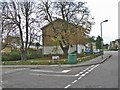
Corner of Garsdale Close, London N11
Corner of Garsdale Close, N11. This is part of a new housing estate.
Image: © Christine Matthews
Taken: 5 Nov 2005
0.13 miles
3
Powerleague Sports Centre, A406 Colney Hatch
Image: © David Howard
Taken: 28 Apr 2009
0.15 miles
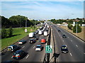
4
A406 B550 intersection on a beautiful August evening
Image: © Chris Whippet
Taken: 5 Aug 2008
0.15 miles
5
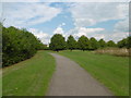
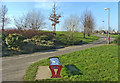
Path in Secret Park
According to Google Earth Secret Park is its name. To the east is Friern Barnet Retail Park, to the south is the North Circular Road, while to the west and north is housing. It is possible to follow footpaths from New Southgate station but they are not signposted, so possibly only those living nearby know the park is here.
Image: © Marathon
Taken: 21 Sep 2016
0.15 miles
6
Secret Park
According to Google Earth Secret Park is its name. To the east is Friern Barnet Retail Park, to the south is the North Circular Road, while to the west and north is housing. It is possible to follow footpaths from New Southgate station but they are not signposted, so possibly only those living nearby know the park is here.
Image: © Marathon
Taken: 21 Sep 2016
0.16 miles
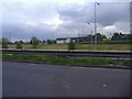
7
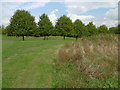
Parkland adjoining the Friern Bridge Trading Estate, N11
Open parkland with footpaths and cycle track on land adjoining the Friern Bridge Trading Estate.
Image: © Christine Matthews
Taken: 7 Feb 2007
0.16 miles
8
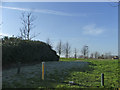
Footpath to bridge over North Circular Road
Looking west from the footpath leading to the bridge over the North Circular Road. On the right we have Atlas Road and on the left behind the trees the eastbound carriage of the North Circular Road (A406). The Friern Park Trading Estate has a one way system of access and exit.
Image: © Christine Matthews
Taken: 21 Jul 2008
0.17 miles
9
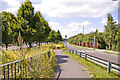
Cycle Track on land adjoining Friern Bridge Trading Estate, N11
Cycle track in parkland adjoining Friern Bridge Trading Estate, leading to housing estate, with bench in foreground.
Image: © Christine Matthews
Taken: 7 Feb 2007
0.18 miles
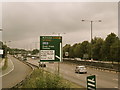
10
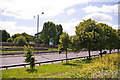
North Circular Road (A406) from Atlas Road
Looking down on the North Circular Road from Atlas Road, the access road for the Friern Park Trading Estate.
Image: © Christine Matthews
Taken: 21 Jul 2008
0.18 miles